Coupled
land/atmosphere interactions in the West African Monsoon
Semyon A. Grodsky, and James A. Carton
Submitted to Geophysical Research Letters
November 6, 2000
Revised: January 25, 2001
Department of Meteorology, University of Maryland, College Park, MD 20742
Text (rainfall_3.doc), pictures (figure?.eps), or text+pictures (rainfall.pdf).
Abstract
Rainfall in subSaharan West Africa is concentrated in a rainy season beginning in summer whose arrival is of critical importance for local economies. Here we use new surface wind observations made available by the QuickSCAT satellite and rainfall estimates from the Tropical Rainfall Measuring Mission to provide the first documentation of a biweekly oscillation in rainfall and wind that precedes the onset of the rainy season. This oscillation in rainfall occurs in conjunction with monsoonal wind patterns and is particularly noticeable in the zonal wind field. It is also associated with a cooling of surface temperature and a reduction in zonal surface pressure gradient. Together the phasing of these variables implies feedback cycle acting between the monsoonal winds and their clouds, soil moisture and surface temperature.
1.
Introduction
Intensive study of synoptic-scale disturbances over central and West Africa and the tropical Atlantic has revealed the existence of two types of westward propagating wave-like fluctuations. The first are the African Waves with zonal wavelengths of 2,500-3,000 km, periods of 3-5 days, and westward speeds of 9-10 m/s and which are most evident in the meridional component of winds [Carlson, 1969; Reed et al., 1988; Viltard et al., 1997]. The second type has longer 6-9 day periods, correspondingly longer 6000 zonal wavelengths, and higher 11 m/s westward speeds [Yanai and Mukarami, 1970; Cadet and Houston, 1984; Diedhiou et al., 1998]. These latter wave-like fluctuations have their strongest expressions in zonal surface wind and cloud cover in the latitude band 100-200N[Oubuih et al., 1999]. Here we report on a third class of intraseasonal disturbances in the winds of the eastern tropical Atlantic, which however occur closer to the equator and do not propagate westward. This latest example seems to be the result of interactions between the continental hydrologic cycle, summertime heating, and the tropical trade wind system and influences summertime rainfall over the countries of the northern Gulf of Guinea.
2.
Data and results
The study is based on highly detailed surface wind observations that have become available from the SeaWinds scatterometer aboard the QuickSCAT satellite in the last year beginning mid-July 1999 [Spencer et al., 2000]. It is equipped with a specialized radar providing estimates of near-surface wind velocity at 25 km resolution over 90% of the ice-free ocean on a daily basis [Graf et al., 1998]. Scatterometer wind has an accuracy of about 2 m/s and 170-200 angle as reported by the developers in publication at http://128.149.33.88/seaflux/html/nrt_release_note.html. The satellite was launched in mid-June, 1999 and data has been available since 19 July 1999. Daily wind used in this study spans the first two summers (August, 1999 - September, 2000) on a 0.50 x 0.50 grid. The wind retrieval and gridding methodology is constantly under improvement. Past development is described in Tang and Liu [1996] and Liu et al. [1998].
We have
analyzed these in conjunction with tropical rainfall estimates are based
on a combination of the Microwave Imager, and the Precipitation Radar,
that form part of the Tropical Rainfall Measuring Mission (TRMM) satellite
sensor suite [Kummerow et al., 1998]. The data used in this study
are the TRMM 3G gridded rainfall 3G68 products. The description of the
rainfall retrieval algorithms and data validation is given in Iguchiet
al. [2000], Chang et al. [1999], and Kummerow et al.
[2000].
The wind
field of West Africa and the tropical Atlantic consists of two trade wind
regimes, the hot, dry, dusty Northeast trades, also known as the Harmattans
on the continent, and the cooler, moister Southeast trades (Figure
1). The boundary between these trade wind systems is defined by
the InterTropical Convergence Zone (ITCZ), which presents a narrow band
of heavy rainfall. The position of these trade wind systems changes seasonally.
During late May the ITCZ lies between the equator and 80N. By
late June it has shifted 50 further north. However, as Figure
2 reveals, the pattern of winds and rainfall can undergo rapid
changes as well. In the five days following 17 May trade wind systems develop
an eastward monsoonal flow. This change brings moist maritime air eastward
onto the savannah-covered Sudan as well as the wetter climatic zone to
the south resulting in intermittent heavy rainfall at least a month prior
to the annual rainy season. The eastward shift of convection causes a corresponding
reduction in rainfall in the western side of the basin. During the succeeding
week (early June) the winds return to their normal configuration, while
convection shifts westward onto the ocean and towards eastern Brazil.
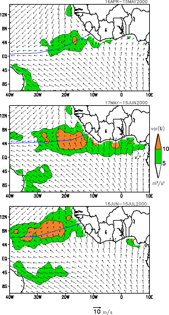
Figure 1. Monthly average scatterometer winds mid-April to mid-July, 2000. Contours show the intra-monthly variance of wind velocity. The maximum variance shifts northward and intensifies throughout the summer indicating a shift of the quasi-biweekly disturbances. The approximate location of the Intertropical Convergence Zone is indicated with a dashed line. |
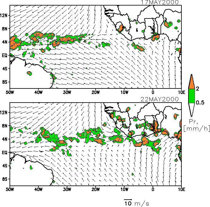
Figure
2. Two-day average surface winds and rainfall obtained from scatterometry
and TRMM microwave measurements. Upper panel shows 16-18 May. Lower panel
shows 21-23 May. Rates exceeding 0.5 mm/hr are shaded. Note the rapid change
in direction and rainfall pattern. This pattern has switched back by 30
May.
|
Time series
of the zonal winds off Northwest Africa reveal that this wind disturbance
is in fact one of a succession of reversals of the direction of the trade
winds that develop first close to the equator in April. By early May the
disturbances are evident between 40 and 60N as shown
in Figure
3, while by mid-June they make their appearance at 80
N. In each latitude band they persist for approximately 2 months. The timing
of these disturbances follows the northward march of the ITCZ. The duration
of the oscillations at particular latitude location is determined by the
balance between the meridional width of the area occupied by oscillations
(see Figure
1) and the speed of the northward march of the ITCZ. Correlation
of these fluctuating zonal winds with rainfall shows a strong relationship
throughout the continental areas surrounding the Gulf of Guinea (Figure
4).
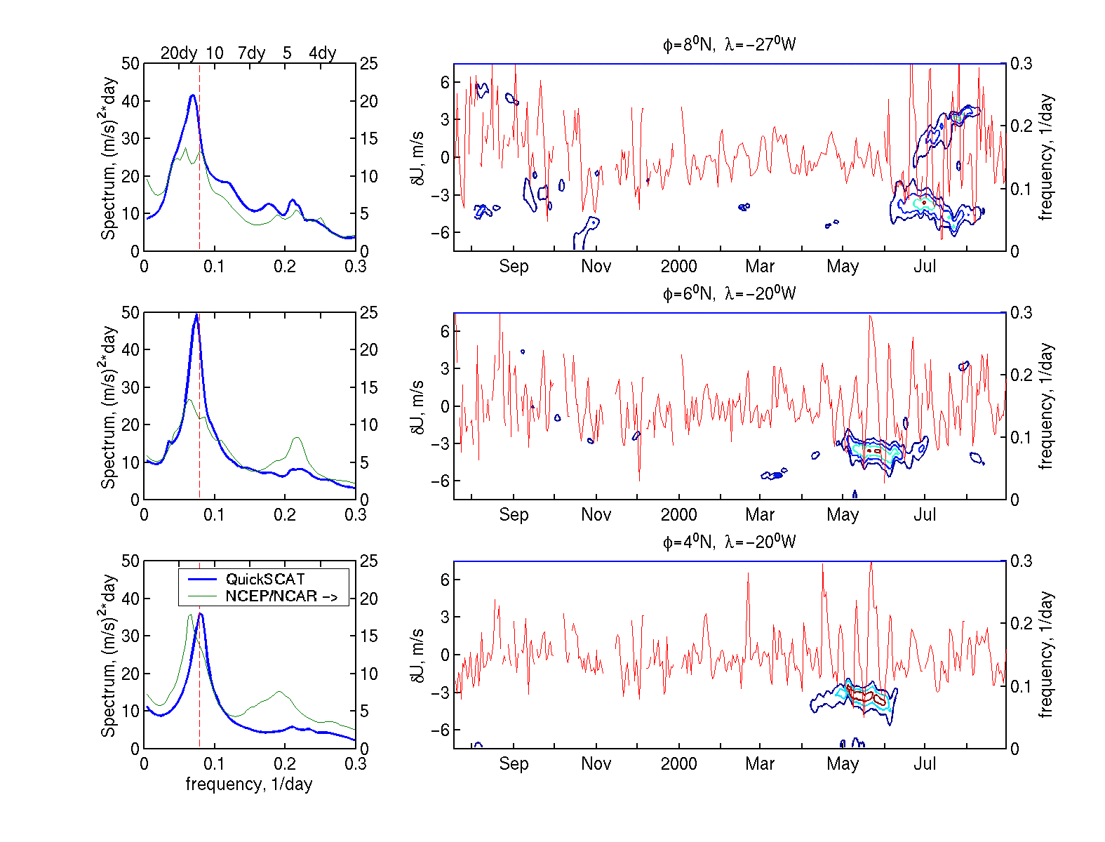
Figure 3. Zonal surface wind at three locations off the Northwest Africa: (40N, 200W), (60N, 200W), and (80N, 270W) for one year beginning mid-July, 1999 obtained from scatterometry. A 2-month running mean has been removed to focus attention on intraseasonal variability. Time series in the righthand panels show amplitude with time (scale on lefthand side), while contours show power with frequency and time (scale on righthand side). The contours are drawn at [62.5 125 250 500] m2s-2day-1 levels. Left-hand panels compare power spectrum for the scatterometer zonal winds (lefthand y-axis) with the corresponding power spectrum for zonal surface wind from the NCEP/NCAR reanalysis (righthand y-axis). Vertical dashed lines correspond to 12.5 day period. |
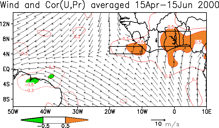
Figure 4. Correlation between the zonal component of wind (averaged 200W-100W, 40N-60N) with rainfall in Northwest Africa computed during the two-month period beginning 15 April. Correlations exceeding 0.5 are shaded. |
Previous studies of waves in the northeast trade winds have identified periodicities ranging from 3-9 days [Carlson, 1969; Burpee, 1972; Reed et al., 1988; Viltard et al., 1997]. Here we estimate the frequency of these new disturbances by decomposing the 409-day record into overlapping 32-day time series. Each is detrended using a linear least squares estimate. The power spectrum is then computed using the maximum entropy method with autoregressive parameter equaling 10, i.e. 1/3 of the realization length [see e.g. Kay and Marple, 1981]. The results, shown as contours in Figure 3 reveal disturbances with periods of 10-15 days at 40N, while the same are also observed at all latitudes between 20 and 100N. Shorter 3-5 day waves are also evident poleward of 80 N. The average spectra for the full time series show that most of the variance is in the zonal component of winds (the meridional component spectra are not shown in Figure 3) and that the period of oscillation is close to quasi-biweekly with maximum at 12.5 days at all latitudes between 20 and 100N with most of the energy confined to the 10-15-day band. Comparison of winds at various locations does not indicate any zonal propagation of these disturbances.
In the discussion above we have described these quasi-biweekly disturbances based solely on satellite observations. We confirm these results by comparing them to the NCEP/NCAR reanalysis of Kalnay et al. [1996]. This reanalysis combines an independent suite of observations along with a numerical model of the fluid dynamic equations of motion to provide a best estimate of the evolving three-dimensional state of the atmosphere. Because of their recent availability neither QuickSCAT winds, nor TRMM rainfall have been incorporated in the reanalysis as yet and thus a comparison with reanalysis represents independent validation.
Here we compare spectra from reanalysis winds computed in the same way as the scatterometer spectra (Figure 3 , left panels). The spectra reveal the presence of quasi-biweekly disturbances in the reanalysis winds, but of lower amplitude than in the QuickSCAT winds. At 40N the spectral power of quasi-biweekly disturbances in the reanalysis winds is half that of the QuickSCAT winds, while by 80N the spectral level is only 1/3 - 1/4, indicating wind anomalies that are half as large probably because of the lack of direct wind observations used by reanalysis. Interestingly, the reanalysis winds have 3-5 day African Waves of similar amplitude to those in the QuickSCAT winds.
The discussion
above has left open the question of the possible nature of these disturbances.
The wind disturbances we observe seem differing from wave-like features
of 3-9 day periods as they don?t possess easterly propagation typical of
waves and their appearance is bounded to relatively narrow area surrounding
the ITCZ. The presence of the quasi-biweekly fluctuations in the reanalysis
zonal winds [also noted by Viltard et al. 1997] allows us to use
the reanalysis to explore the origins of the phenomena. Figure
5 presents time series of several variables April 15-June 15 averaged
in a 100 x 40 longitude/latitude box spanning the
lush coastal regions from Cote d?Ivoire to Nigeria in the Northern Gulf
of Guinea. This box is defined by the region where the correlation between
trade wind fluctuations over the ocean box and rainfall over land exceeds
50% (see
Figure
4).
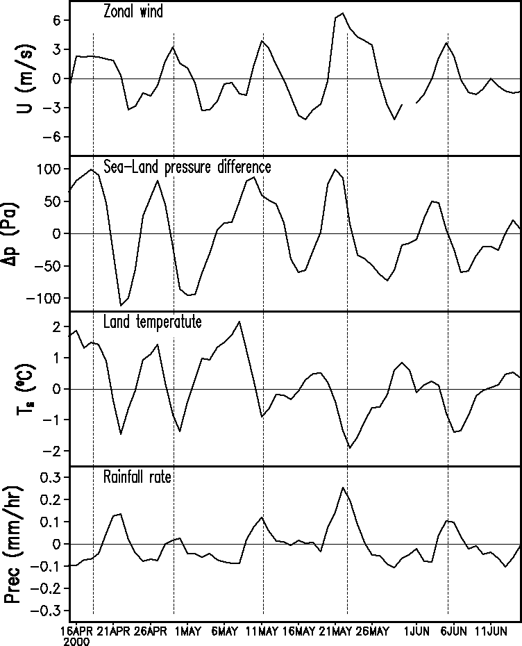
Figure 5. Time series of meteorological variables for the two-month period beginning 16 April averaged in the boxes shown in Figure 4. Surface temperature (50N-100N, 50W-50E), west minus east surface pressure difference, zonal winds (200W-100W, 40N-60N), and rainfall (50N-100N, 50W-50E). |
During this period a succession of five wind disturbances are evident. Each is accompanied by a 10 - 20C increase in surface temperature and is preceded by development of a strong zonal pressure gradient force, which is almost in phase with the zonal acceleration. In response to these changes zonal winds increase their westerly component by 3-6m/s, drawing in moist maritime air. Rainfall rates increase by 0.1 - 0.2 mm/hour. The reduction in surface temperatures in response to the increased moisture and the radiation-reducing effects of clouds contributes to a decrease in the zonal pressure gradient force and a consequent reduction in the westerly component of the winds, which return to their normal direction and strength. The return of the trade winds precedes an increase in surface temperature, and the cycle repeats itself.
The existence of oscillations in the tropical wind system related to feedbacks within the hydrologic cycle is not unique to Northwest Africa. Quasi-biweekly disturbance was reported by Krishnamurti and Bhalme [1976] in the Indian monsoon system. Lau and Bua [1998] present additional modeling evidence of a similar phenomenon occurring in the region of East Asia/Indochina. These studies provide further evidence of strong interactions between continental and maritime atmospheric processes and the hydrologic cycle and sound that quasi- biweekly period is an important time scale of oscillation in the monsoon-like system that develops due to its own inherent dynamics. The bi-weekly period of the oscillations and explanation we offer to describe their origin have obvious parallels to the bi-weekly disturbances discovered by Krishnamurti and Bhalme [1976] in the Indian monsoon.
References
Burpee, R.W., The origin and structure of easterly waves in the lower troposphere in North Africa, J. Atmos. Sci., 29, 77-90, 1972.
Carlson, T.N, Some remarks on African disturbances and their progress over the tropical Atlantic, Mon. Wea. Rev., 97, 716-726, 1969.
Cadet, D.L., and O.N. Nnoli, Water vapor transport over Africa and the Atlantic Ocean during summer 1979, Quart. J. Roy. Meteor. Soc., 113, 581-602, 1987.
Chang, A.T.C., L.S. Chiu, C. Kummerow, J. Meng, T.T. Wilheit, First results of the TRMM microwave imager (TMI) monthly oceanic rain rate: Comparison with SSIM/I, Geoph. Res. Let., 26, 2379-2382, 1999.
Diedhiou, A., S. Janicot, A. Viltard, and P. de Felice, Evidence of two regimes of easterly waves over West Africa and the tropical Atlantic, Geophys. Res. Let., 25, 2805-2808, 1998.
Graf, J., C. Sasaki, C. Winn, W.T. Liu, W. Tsai, M. Freilich, and D. Long, NASA Scatteromometer Experiment. Acta Astronautica, 43, 397-407, 1998.
Iguchi T, T. Kozu, R. Meneghini, J. Awaka, K. Okamoto, Rain-profiling algorithm for the TRMM precipitation radar, J. Appl. Meteor., 39, 2038-2052, 2000.
Kalnay, E., M. Kanamitsu, R. Kistler, W. Collins, D. Deaven, L. Gandin, M. Iredell, S. Saha, G. White, J. Woolen, Y. Zhu, M. Chelliah, W. Ebisuzaki, W. Higgins, J. Janowiak, K.C. Mo, C. Ropelewski, J. Wang, A. Leetmaa, R. Reynolds, R. Jenne, and D. Joseph, The NCEP/NCAR 40-year reanalysis project, Bull. Amer. Meteorol. Soc., 77, 437-471, 1996.
Kay, S.M., and S.L. Marple, Spectrum analysis - a modern perspective, Proc. IEEE, 69, 1380-1419, 1981.
Krishnamurti, T.N., and H.N. Bhalme, Oscillations of a monsoon system. Part I. Observational aspect, J. Atmos. Sci., 33, 1937-1954, 1976.
Kummerow, C., W. Barnes, T. Kozu, J. Shiue, and J. Simpson, The Tropical Rainfall Measuring Mission (TRMM) sensor package, J. Atmos. And Ocean. Tech., 15, 809-817, 1998.
Kummerow, C., J. Simpson, O. Thiele, W. Barnes, A. T. C. Chang, E. Stocker, R. F. Adler, A. Hou, R. Kakar, F. Wentz, P. Ashcroft, T. Kozu, Y. Hong, K. Okamoto, T. Iguchi, H. Kuroiwa, E. Im, Z. Haddad, G. Huffman, B. Ferrier, W. S. Olson, E. Zipser, E. A. Smith, T. T. Wilheit, G. North, T. Krishnamurti, K. Nakamura, The Status of the Tropical Rainfall Measuring Mission (TRMM) after Two Years in Orbit. J. Applied Meteor., 39, 1965-1982, 2000.
Lau, K-M., and W. Bua, Mechanism of monsoon-Southern Oscillation coupling: insights from GCM experiments, Climate Dynamics, 14, 759-779, 1998.
Liu, W.T., W. Tang, and P.S. Polito, NASA Scatterometer provides global ocean-surface wind fields with more structures than numerical weather prediction. Geophys. Res. Lett.,25, 761-764, 1998.
Oubuih, J., P. de Felice, and A. Viltard, Influence of the 6-9 day wave disturbances on temperature, vorticity and cloud cover over the tropical Atlantic during summer 1985, Meteorol. Atmos. Phys., 69, 137-144, 1999.
Reed, R. J., A. Hollingsworth, W.A. Heckley, and F. Delsol, An evaluation of the performance of the ECMWF operational system in analyzing and forecasting easterly wave disturbances over Africa and the tropical Atlantic, Mon. Wea. Rev., 116, 824-865, 1988.
Spencer, M.W., C.L. Wu, and D.G. Long, Improved resolution backscatter measurements with the Sea Winds pencil-beam scatterometer, IEEE Trans. Geosci. Rem. Sens., 38, 2642-2652, 2000.
Tang, W., and W.T. Liu, Objective Interpolation of Scatterometer Winds. JPL Publication 96-19, Jet Propulsion Laboratory, Pasadena, 16 pp., 1996.
Viltard, A., P. de Felice, and J. Oubuin, Comparison of the African and 6-9 day wave-like disturbance pattern over West-Africa and the tropical Atlantic during summer 1985, Meteorol. Atmos. Phys., 62, 91-99, 1997.
Yanai,
M., and M. Murakami, Spectrum analysis of symmetric and anti-symmetric
equatorial waves, J. Meteor. Soc. Japan, 48, 331-346, 1970.
Figure Legends
Figure 1.Monthly
average scatterometer winds mid-April to mid-July, 2000. Contours show
the intra-monthly variance of wind velocity. The maximum variance shifts
northward and intensifies throughout the summer indicating a shift of the
quasi-biweekly disturbances. The approximate location of the Intertropical
Convergence Zone is indicated with a dashed line.
Figure 2. Two-day average surface winds and rainfall obtained from scatterometry and TRMM microwave measurements. Upper panel shows 16-18 May. Lower panel shows 21-23 May. Rates exceeding 0.5 mm/hr are shaded. Note the rapid change in direction and rainfall pattern. This pattern has switched back by 30 May.
Figure 3.Zonalsurface wind at three locations off the Northwest Africa: (40N, 200W), (60N, 200W), and (80N, 270W) for one year beginning mid-July, 1999 obtained from scatterometry. A 2-month running mean has been removed to focus attention on intraseasonal variability. Time series in the righthand panels show amplitude with time (scale on lefthand side), while contours show power with frequency and time (scale on righthand side). The contours are drawn at [62.5 125 250 500] m2s-2day-1 levels. Left-hand panels compare power spectrum for the scatterometer zonal winds (lefthand y-axis) with the corresponding power spectrum for zonal surface wind from the NCEP/NCAR reanalysis (righthand y-axis). Vertical dashed lines correspond to 12.5 day period.
Figure 4. Correlation between the zonal component of wind (averaged 200W-100W, 40N-60N) with rainfall in Northwest Africa computed during the two-month period beginning 15 April. Correlations exceeding 0.5 are shaded.
Figure 5. Time series of meteorological variables for the two-month period beginning 16 April averaged in the boxes shown in Figure 4. Surface temperature (50N-100N, 50W-50E), west minus east surface pressure difference, zonal winds (200W-100W, 40N-60N), and rainfall (50N-100N, 50W-50E).