Intertropical
Convergence Zone in the South Atlantic and the equatorial cold tongue
Semyon A. Grodsky, and James A. Carton
October 26, 2001
Revised
March 22, 2002
Accepted May 28,2002
Please use the NETSCAPE browser.
Department of Meteorology, University of Maryland, College Park, MD 20742
Abstract. Recent observations from the QuickSCAT and Tropical
Rainfall Measuring Mission satellites, as well as a longer record of Special
Sensor Microwave Imager winds are used to investigate the existence and
dynamics of a Southern Hemisphere partner to the Intertropical Convergence
Zone in the tropical Atlantic Ocean. It extends eastward from the coast
of Brazil in the latitude band 100S - 30S and is
associated with seasonal precipitation exceeding 6 cm/month during peak
months over a part of the ocean characterized by high surface salinity.
It appears in austral winter when cool equatorial upwelling causes an anomalous
northeastward pressure gradient to develop in the planetary boundary layer
close to the equator. The result is a zonal band of surface wind convergence
that exceeds 10-6 1/s, rainfall stronger than 2 mm/day, and
an associated decrease in the ocean surface salinity averaged at 0.2 ppt.
1.Introduction
Rainfall in the tropical Atlantic is organized into several convective zones.North of the equator convergence of the winds associated with the meridional Hadley circulation produces a zone of intense convection, which on monthly timescales is organized into the Intertropical Convergence Zone (ITCZ) [see e.g. Hastenrath and Lamb, 1978]. Rainfall in the southern subtropics is distinguished by the presence of the South Atlantic Convergence Zone (SACZ), which extends southeastward from the great continental convective zone of tropical South America and is generated by moisture convergence between the South Atlantic high pressure and the continental thermal low pressure zones. The SACZ reaches maximum intensity in austral summer (here and after the seasons are generally named relative to the Southern Hemisphere) in phase with intensifying continental heating and convection.Between the two there lies a dry zone of general subsidence and surface divergence.Here we present satellite-based observations of a third poorly documented convective zone, whose appearance is closely connected to seasonal changes in SST.This Southern Intertropical Convergence Zone (SITCZ) is a feature of the climatological austral winter and is an important source of fresh water to the ocean in an otherwise strongly evaporative band of latitudes.
Zonally elongated atmospheric convective zones are a common feature of tropical climate.The most prominent of these features in the Atlantic and eastern Pacific is the ITCZ.The ITCZ lies at the junction between the northeast and southeast trade wind systems and is indicated by a narrow (a few degrees wide) band of surface wind convergence and a reduction in wind speed. The latitudinal position of the ITCZ in the Atlantic varies from a minimum close to the equator in boreal spring (March-May) in the west to a maximum extension of 100N-150N in late boreal summer (August) in the east.The ITCZ is also closely associated with a band of convective clouds and rainfall, which provides a large source of diabatic heat to the troposphere, and fresh water to the ocean.
The dynamics controlling the intensity of the trade wind systems in the tropical Atlantic and the ITCZ is a result of complex processes in which continental convection and influences from the other basins play an important part as well as the seasonally and interannually varying SST of the Atlantic Ocean [Enfield and Mayer, 1997; Chiang et al., 2001; Ruiz-Barradas et al., 2001].The northeastward slant of the ITCZ mirrors the appearance of warm (>200C) SSTs that also undergo a meridional migration with season.Year-to-year fluctuations in the meridional gradient of SST in boreal spring give rise to fluctuations in the southernmost extent of the ITCZ by several hundred kilometers [Ruiz-Barradas et al., 2000] with severe implications for the climate of the northeastern region of Brazil.
The northward migration of the ITCZ in late northern spring causes a northward shift of the zone of Ekman downwelling south of the ITCZ as well as the zone of strong Ekman upwelling to the north. These changes produce a trough-ridge structure in the oceanic thermocline and a geostrophically balanced eastward North Equatorial Countercurrent. Seasonal changes in surface wind speed and cloud cover, in turn, give rise to strong seasonal variations in surface latent heat release and net solar heating, which are important terms in the heat balance of the oceanic mixed layer in the tropical Atlantic [Carton and Zhou, 1997]. Fresh water flux can potentially influence the subduction of warm tropical waters as well.
Although less prominent than the ITCZ, the eastern tropical Pacific has a second convective zone, the SITCZ lying south of the equator in the band of latitudes between 100S and 30S [Kornfield et al., 1967; and Hubert et al., 1969].This second convective zone is strongly seasonal, appearing only in austral autumn (March-May) in the longitudinal sector east of 1400W.Recently Leitzke et al. [2001] and Halpern and Hung [2001] have examined the links between the seasonal change in SST and the appearance of the SITCZ.Halpern and Hung [2001] have shown that the development of gradients in SST associated with the presence of a seasonal tongue of cool SST along the equator and warming of the southern hemisphere in austral autumn give rise to the SITCZ through SST-induced meridional wind convergence.Strikingly, the SITCZ does not form in El Nino years when the cold tongue is absent [Zheng et al., 1997; Leitzke et al., 2001].
Much less is known about convection in the southern tropics in the Atlantic sector.The earliest indication of the SITCZ appears to have been in a report by Belevich et al. [1976], describing results from the Soviet TROPEX-74 research program. Wind convergence and convection, which appears to be associated with an SITCZ is also evident in the July-August climatology of Hastenrath and Lamb [1978], (see their Figure 1d) based on ship reports. Interestingly, a later analysis of the July-August bimonthly surface wind and OLR by Aceituno [1988] (see his Figure 4) did not show this feature.
In this study we exploit the recent availability of an array of satellite-based products to describe the kinematics of the SITCZ in the Atlantic and to explore its connection to the development of strong SST gradients along the equator during austral winter.
Three satellite-based surface wind analyses are used in this study.The primary wind data set is the data from the SeaWinds scatterometer aboard the QuickSCAT satellite [Graf et al., 1998]. The QuickSCAT radar has a continuous 1800 km swath and covers 93% of the ocean each day. The wind estimates have an accuracy of 2 m/s in speed and 17-20 degrees in direction (winds in this area have typical speeds of 5-10 m/s). The data was obtained from the QuickSCAT web site at NASA/JPL where it is available optimally interpolated onto a regular 0.50x0.50 - 1day grid as described by Polito et al. [2000]. The QuickSCAT winds are available from mid-July, 1999 until the end of our observation period in September, 2001.The longer Special Sensor Microwave Imager (SSMI) wind velocity record of Atlas et al. [1996] is available for the 13-year period, 1988-2000, but only on a coarser 10x10 grid. Wind direction for the SSMI velocity is provided by the European Center for Medium Range Weather Forecasts analysis product. ERS 1/2 scatterometer wind velocity of Bentamy et al. [2001] is available during the 9 year period 1992-2000 on a 10x10 grid.
Our rainfall data set is based on a combination of measurements from the Tropical Rainfall Measuring Mission (TRMM) Microwave Imager and the Precipitation Radar aboard the US/Japanese TRMM satellite [see Kummerow et al., 2000, and references therein].The data used in this study are the TRMM 3G68 daily combination rainfall products, which are available on a 0.50x0.50 grid from late - 1997 through 2001. Recent estimates of Bell et al. [2001] have shown that the accuracy of the TRMM rainfall retrievals depend on rainfall rate and is 35% and 30% at 2 mm/dy and 4 mm/dy, respectively. For additional comparisons the SSMI-derived rain rate is used [Wentz, 1997; Wentz and Spencer, 1998].
For surface air pressure we need to rely on the NCEP/NCAR daily reanalyses of Kalnay et al. [1996], available on a 2.50x2.50 grid.Because of the limited number of direct observations over the oceans we can anticipate that surface air pressure estimates will be noisy. For wind velocity and precipitation we also used the climatology provided by the Atlas of Surface Marine Data - 94 of da Silva et el. [1994] based on the Comprehensive Ocean Atmosphere Data Set (COADS). The SST used in this study is the National Centers for Environmental Prediction SST analysis based on a combination of in situ SST observations and satellite infrared radiances [Reynolds and Smith, 1994]. Finally, in order to examine the impact of precipitation on the upper layers of the ocean we examine the historical sea surface salinity data of Dessier and Donguy [1994] in comparison with historical ship drift surface currents available on the Ocean Current Drifter Data CD-ROM provided by NOAA/NODC. This surface salinity data has been collected by several means, including engine intake salinometers and bucket measurements.Because of data coverage limitations, we combine observations from many years in order to construct a meaningful seasonal climatology.
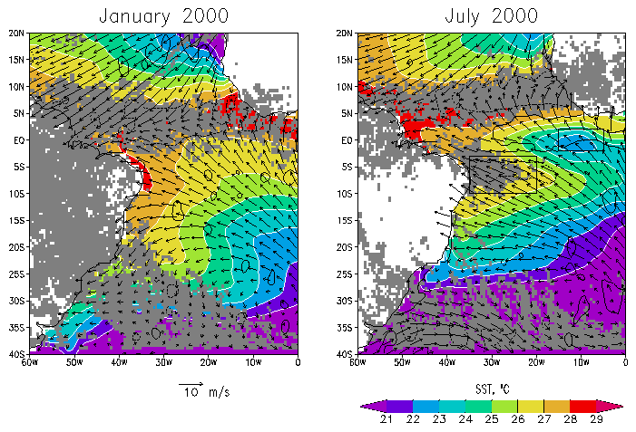
By July
the ITCZ shifts northward, with increasing convection in the eastern half
of the basin and reduced convection over the South American continent (Fig.
1, July panel).The South Atlantic
Convergence Zone is reduced in strength, while the SITCZ is visible extending
eastward from Brazil in the band of latitudes 100S-30S.It
is evident that much of the SITCZ convection is confined to the domain
100S-30S, 350W-200W.We
will thus use this region for the purpose of constructing SITCZ indices
of rainfall, wind divergence, etc.
 |
|
Figure
1. Monthly average SST (colors), winds (vectors), and rainfall exceeding
2 mm/day (gray) for January, 2000 and July, 2000. Wind divergence is contoured
at two levels -5*10-6 1/s and 5*10-6 1/s with dashed
and solid lines, respectively. The SITCZ index region (350W-200W,
100S-30S) and the cold tongue region (150W-50W,
20S-20N) are indicated by rectangles.
|
 |
|
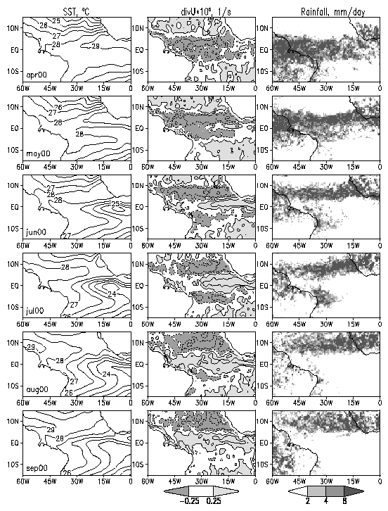
Figure
2. SST, wind divergence, and rainfall (mm/day) over the tropical Atlantic
during April - September 2000. Wind divergence and convergence are shown
with solid and dashed lines, respectively, starting from 2.5x10⁻⁶
1/s with a 5x10⁻⁶ 1/s contour interval.
|
 |
|
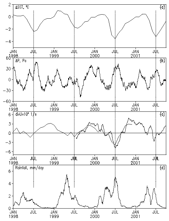
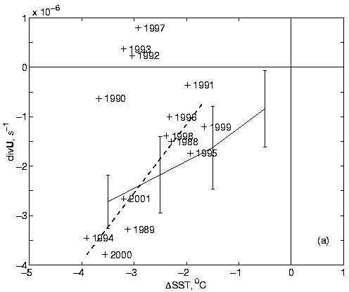
Figure
3.Monthly-averaged meteorological
and oceanic time series for 1998-2001.(a)
Difference in SST,
|
 |
|
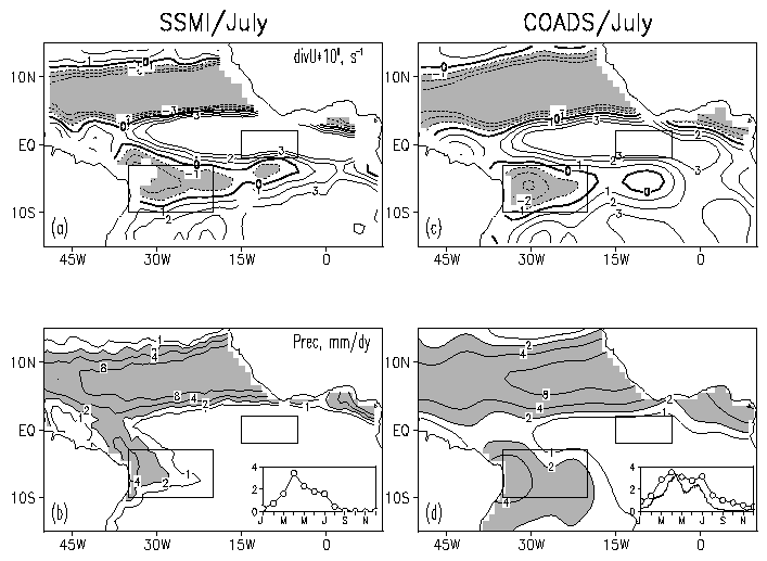
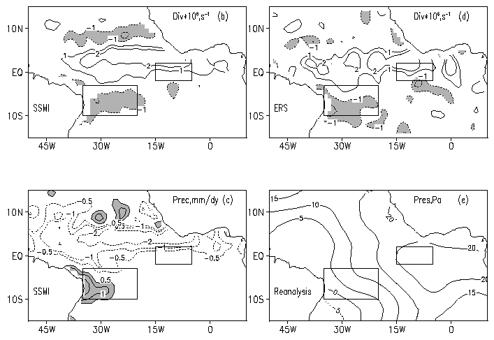
Figure
4. July climatology of
the near surface wind divergence and precipitation from SSMI and COADS.
The boxes show the SITCZ and the cold tongue index regions. The inlays
present climatological rainfall averaged over the SITCZ area. The COADS
panel shows also the TRMM rainfall.
|
 |
 |
|
Figure
5. (a) July wind divergence in the SITCZ index region and SST
difference between the cold tongue and the SITCZ regions. Dashed line is
a linear fit to 10 years of data excluding of 1990, 1992-93, and 1997.
Vertical bars are the limits of
|
We assume
a well-mixed boundary layer in which there is a three-term balance among
Coriolis effects, ![]() ,
pressure gradient forces,
,
pressure gradient forces,![]() ,
and linear friction,
,
and linear friction, ![]() :
:
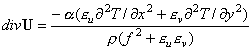 (2)
(2) |
|
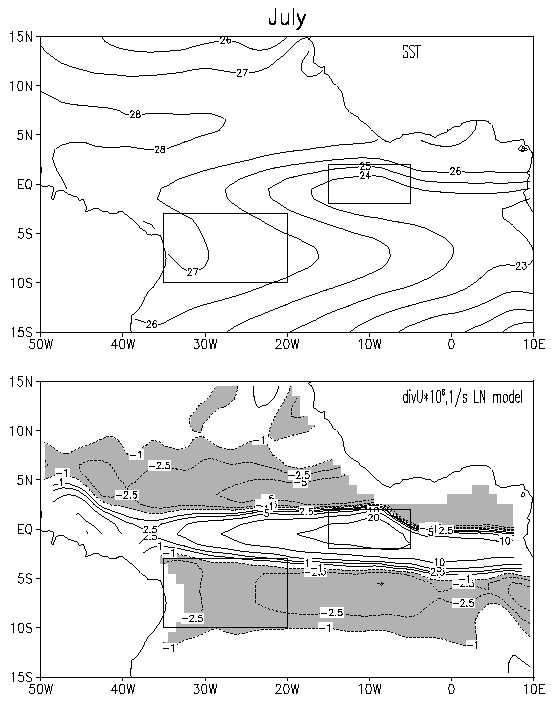
Figure
6. July SST (top) and wind divergence predicted with Lindzen
and Nigam [1987] model (bottom).
|
 |
|
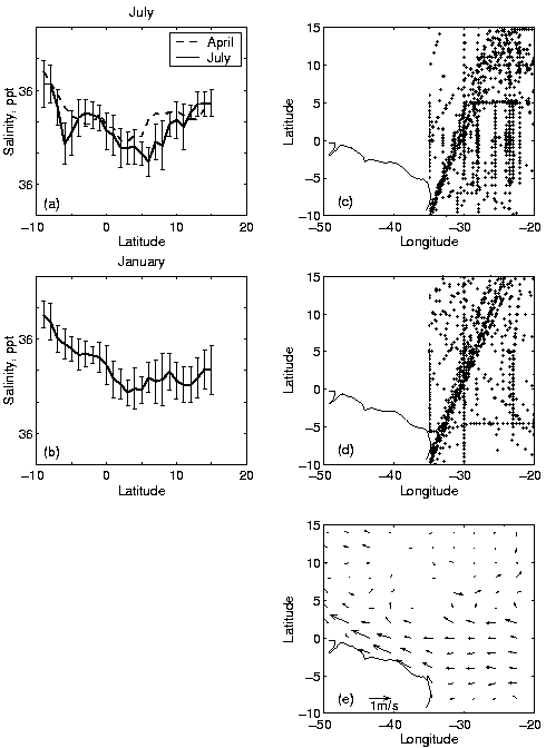
Figure
7. (a) July and (b) January sea surface salinity, S,
averaged between 350W and 200W versus latitude. Vertical
bars are standard deviations of the measurements within 10 latitude
bands. Locations of observation points between 350W and 200W
for(c) July and (d) January. (e)
July surface currents based on historical ship drift.
|
 |
|
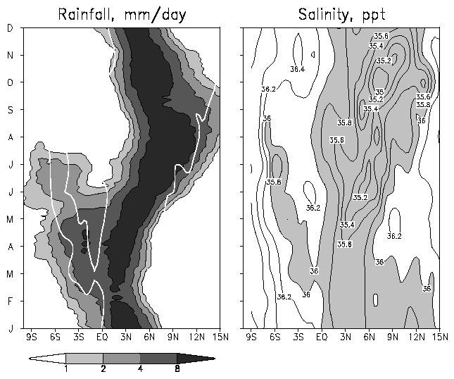
Figure
8. Latitude-time diagrams of the TRMM seasonal rainfall and surface
salinity averaged 350W - 200W. Note that the two
data sets are not contemporaneous. White line in the left panel is 36 ppt
salinity contour.
|
This paper explores the presence and implications of a Southern Intertropical Convergence Zone in the southern hemisphere of the tropical Atlantic.Examination of a variety of primarily remotely sensed observations indicates that an SITCZ does appear in austral winter peaking in July-August, a season when the Intertropical Convergence Zone is displaced well to the north.By austral spring the SITCZ is no longer present.
Surface wind convergence during the austral winter of 2000 in the SITCZ index region (100S-30S, 350W-200W) estimated from QuickScat winds was ~5x10⁻⁶ 1/s, a value which is quite comparable to that found in the ITCZ itself.However, the monthly climatological average based on SSMI and COADS winds gives convergence rates, which are lower by a factor of 2. Despite the wind convergence there is little rotation in the surface wind field in the SITCZ region (because in distinction from the ITCZ there isn?t a calm wind zone), and thus only weak Ekman pumping induced in the surface layers of the ocean. During peak months of some years precipitation may exceed 6 mm/dy, but the average precipitation in the SITCZ index region is ~2 mm/day.
We next consider the role of boundary layer processes in producing the observed surface divergence fields. We find that the seasonal appearance of a cold tongue of SST along the equator sets up pressure gradients within the boundary layer that induce wind convergence in the SITCZ index region of the magnitude observed.Indeed, year-to-year changes in the difference in SST between the cold tongue region and the SITCZ index region explain a significant fraction of the year-to-year variability in SITCZ rainfall.
Finally, we examine the oceanic implications of the seasonal SITCZ.We find that there is a seasonal reduction in sea surface salinity of ~0.2 ppt (averaged over the SITCZ area) in response to seasonal rains. The southern tropics have long been identified as a major source of warm water entering the Equatorial Undercurrent and crossing into the Northern Hemisphere [Metcalf and Stalcup, 1967; Fratantoni et al. 2000], and thus play an important role in climate. Ocean modeling studies will be necessary to exploit this connection.
Acknowledgments
We are grateful to E. Kalnay and S. Nigam of UMD for valuable suggestions. The authors appreciate the support provided by the National Science Foundation (OCE9530220 and OCE9812404). QuickSCAT wind has been obtained from the NASA / NOAA sponsored data system Seaflux, at JPL through the courtesy of W. Timothy Liu and Wenqing Tang. Alain Dessier kindly provided the sea surface salinity observations. The suggestions given by anonymous reviewers were helpful and stimulating. The gridded TRMM rainfall data are available at: http://tsdis.gsfc.nasa.gov/trmmopen/3G68.html. SSMI wind velocities were kindly provided by R. Atlas and J. Ardizzone. The European Research Satellite 1/2 mean wind field atlas is available at http://www.ifremer.fr/cersat/). SSMI precipitation and water content data are produced by Remote Sensing Systems and sponsored, in part, by NASA's Earth Science Information Partnerships (ESIP): a federation of information sites for Earth science; and by the NOAA/NASA Pathfinder Program for early EOS products; principal investigator: Frank Wentz.
References
Chiang, J.C.H., and S.E. Zebiak, 2000: Surface wind over tropical oceans: Diagnosis of the momentum balance, and modeling the linear friction coefficient, J. Clim., 13, 1733-1747.
Chiang, J.C.H, S.E. Zebiak, and M.A. Cane, 2001: Relative roles of elevated heating and surface temperature gradients in driving anomalous surface winds over tropical oceans,J. Atmos. Sci.,58, 1371-1394.
Da Silva, A., A.C. Young, and S. Levitus, Atlas of surface marine data 1994, 1994: NOAA Atlas NESDIS 6, U.S. Department of Commerce, Washington D.C.
Dessier, A., and J.R. Donguy, 1994: The sea surface salinity in the tropical Atlantic between 100S and 300N - seasonal and interannual variations (1977 - 1989), Deep Sea Res., 41, 81-100.
Gill, A.E., 1980: Some simple solutions for heat-induced tropical circulation, Quart. J. Roy. Met. Soc., 106, 447-462.
Graf, J., C. Sasaki, C. Winn, W.T. Liu, W. Tsai, M. Freilich, and D. Long, 1998: NASA Scatteromometer Experiment. Acta Astronautica, 43, 397-407.
Enfield, D.B., and D.A. Mayer, 1997: Tropical Atlantic SST variability and its relation to El Nino Southern Oscillation, J. Geoph. Res., 102, 929-945.
Fratantoni, D.M., W.E. Johns, T.L.Townsend, and H.E.Hurlburt, 2000: Low level circulation and water transport pathways in a model of the tropical Atlantic Ocean, J. Phys. Oceanogr., 30, 1944-1966.
Halpern, D., and C.-W. Hung., 2001: Satellite observations of the southern Pacific intertropical convergence zone during 1993-1998, J. Geoph. Res., 106, 28,107-28,112.
Hastenrath, S., and P. Lamb, 1978: On the dynamics and climatology of surface flow over the equatorial oceans, Tellus, 30, 436-448.
Hubert, L.F., A.F. Krueger, and J.S. Winston, 1969: The double intertropical convergence zone-fact or fiction, J. Atmos. Sci., 26, 771-773.
Kalnay, E., and Coauthors, 1996: The NCEP/NCAR 40-year reanalysis project, Bull. Amer. Meteorol. Soc., 77, 437-471.
Kornfield, J., A.F. Hasler, K.J. Hanson, and V.E. Suomi, 1967: Photographic cloud climatology from ESSA III and IV computer-produced mosaics, Bull. Amer. Meteor. Soc., 48, 878-883.
Kummerow, C., and Coauthors, 2000: The Status of the Tropical Rainfall Measuring Mission (TRMM) after Two Years in Orbit. J. Applied Meteor., 39, 1965-1982.
Leitzke, C.E., C. Deser, and T.H. Vonder Haar, 2001: Evolutionary structure of the eastern Pacific double ITCZ based on satellite moisture profile retrievals, J. Clim., 14, 743-751.
Lindzen, R.S., and S. Nigam, 1987: On the role of sea surface temperature gradients in forcing low-level winds and convergence in the tropics, J. Atmos. Sci., 44, 2418-2436.
Metcalf, W.G., and M.C. Stalcup, 1967: Origin of the Atlantic equatorial undercurrent, J. Geoph. Res., 72, 4959-4975.
Neelin, J.D., and I.M. Held, 1987: Modeling tropical convergence based on the moist static energy budget, Mon. Wea. Rev., 115, 3-12.
Pan, J., X-H. Yan, W.T. Liu, Vector empirical orthogonal function modes of the ocean surface wind variability derived from satellite scatterometer data, 2001: Geoph. Res. Lett., 28, 3951-3954.
Polito, P.S., W.T. Liu, and W.Q. Tang, 2000: Correlation based interpolation of NSCAT wind data, J. Atmos. Ocean. Techn., 17, 1128-1138.
Reynolds, R. W., and T. M. Smith, 1994: Improved global sea surface temperature analyses using optimum interpolation, J. Clim., 7, 929-948.
Ruiz-Barradas, A., J.A. Carton, and S. Nigam, 2000: Structure of interannual-to-decadal climate variability in the tropical Atlantic Ocean, J. Clim., 13, 3285-3297.
Servain, J., 1991: Simple climatic indices for the tropical Atlantic Ocean and some applications, J. Geoph. Res., 96, 15,137-15,146.
Wagner, R.G., and A.M. Da Silva, 1994: Surface conditions associated with anomalous rainfall in the Guinea coastal region, Int. J. Clim., 14, 179-1999.
Wentz F. J., 1997: A well-calibrated ocean algorithm for SSM/I, J. Geoph. Res., 102, 4, 8703-8718.
Wentz, F. J., and R. W. Spencer, 1998: SSM/I Rain Retrievals within a Unified All-Weather Ocean Algorithm, J. Atmos. Sci., 55, 1613-1627.
Zheng,
Q., X.-H. Yan, W.T. Liu, W. Tang, and D. Kurz, 1997: Seasonal and interannual
variability of atmospheric convergence zones in the tropical Pacific observed
with ERS-1 scatterometer, Geoph. Res. Lett., 24, 261-263.