Assessment of surface heat fluxes from regional models
Ernesto H. Berbery
Department of Meteorology
University of Maryland
Kenneth Mitchell
EMC/NCEP/NOAA
Stanley Benjamin and Tatiana Smirnova
FSL/ERL/NOAA
Harold Ritchie, Richard Hogue and Ekaterina Radeva
Atmospheric Environmental Service, Canada
The GEWEX Continental-scale International Project (GCIP) has as one of its goals to evaluate
the land surface and atmospheric parameterizations from regional numerical weather prediction
models and their associated 4-dimensional data assimilation systems. In recent years there has
been an important improvement in the way basic variables are being represented in models, and a
host of new parameters that result from physical parameterizations has become available as well.
Soil moisture, evaporation and surface energy balance terms are some examples. Although it
would be desirable to have reliable observations to evaluate the quality of those parameters,
unfortunately this is not always the case. As an alternative, we have undertaken an assessment of
the products of three operational regional models to ascertain their current status in terms of
surface energy budget terms. Partial results for August 1997 are reported in this note. The
assessment has the objective of helping detect potential inaccuracies in the parameterizations and
provide an estimate of the reliability of surface energy budgets specifically for the Mississippi
River Basin. The models in this study are (a) the Eta model from the National Centers for
Environmental Prediction (NCEP); (b) the Global Environmental Multiscale (GEM) model from
the Canadian Meteorological Centre and (c) the Mesoscale Analysis and Prediction System
(MAPS) from NOAA's Forecast Systems Laboratory. As a matter of interest, the corresponding
NCEP/NCAR Reanalysis fields (Kalnay et al., 1996) are also presented.
TABLE 1. Models Features
| Eta | MAPS | GEM | Rean | |
| Horizontal Resolution | 48 km | 40 km | 35 km | T62
(about 210 km) |
| Vertical levels | 38 | 40 | 28 | 28 |
| Convective scheme | Modified Betts-Miller | Modified Grell | Kuo | Pan-Grell |
| Land Surface scheme | Extended
Pan-Mahrt |
6-level soil/veg model - Smirnova | Force-restore scheme | Pan-Mahrt |
| Radiation | GFDL Package | MM5 | CMC/RPN package | GFDL Package |
Table 1 presents basic features of the models. They have approximately a similar resolution over the GCIP area, although they have different advanced parameterizations for radiation, land surface processes, cloud physics and convection. Relevant information on the parameterizations can be found in Chen et al. (1996) and Rogers et al. (1996) for the Eta model; in Smirnova et al. (1996) for MAPS; and in Côté et al. (1997) for the GEM model. Each has its own advantages, for example, the Eta model has available a large number of products; MAPS analyses and forecasts are attractive because of their hourly frequency; the GEM model, while being global, has a variable grid that allows high resolutions over a region of interest. It should be noted that the land surface and radiation physics packages are similar between the Eta and Reanalysis models, so this may be responsible for some of the similarity in results from these two models. Since all the models have different grids and to facilitate the comparison, output fields were interpolated to a common grid known as AWIPS 212. Some significant model corrections have already occurred since the month chosen for comparison in this study. Two changes relevant to this study have been made to the MAPS model since August 1997; a fix to a rooting depth error that had caused underestimates of latent heat flux, and a fix to surface layer mixing at night that had led to insufficient negative sensible heat fluxes.
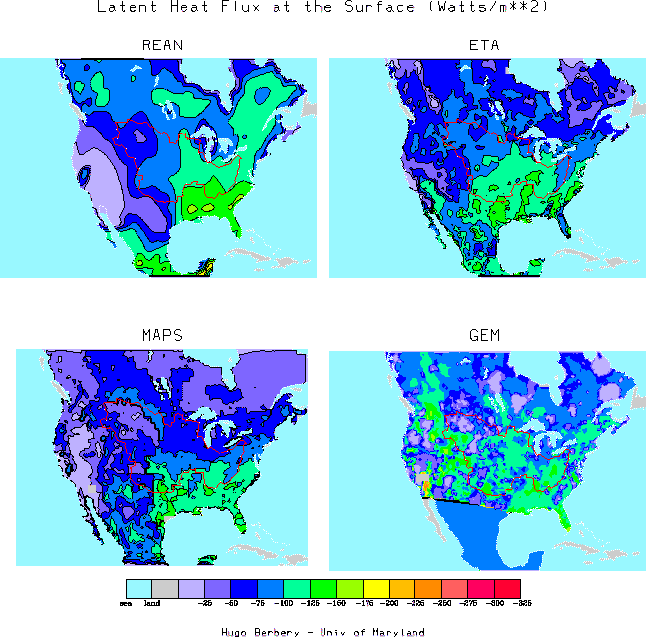
Figure 1. Latent Heat Flux at the surface for August 1997. The red contour is the boundary of the
Mississippi River Basin.
Figures 1-2 display the August 1997 monthly average of the latent and sensible heat fluxes at the
surface. Mean fields were computed as the 31-day average of the 0-12 hour forecasts of the 0 and
12 UTC cycles. Fig. 1 depicts the loss of energy at the surface by latent heat flux (LHF). The
general pattern from all models shows smallest values on the west and increasing toward the
southeast. It can be noted that while GEM fields are noisier, the values are of the same order of
magnitude of those of the other models. It would appear that models tend to show better
agreement inside the Mississippi River Basin, a fact that may be explained because of the
region's abundance of data that are ingested by the assimilating systems and also because in
many instances they serve to tune the parameterization schemes. Interestingly, LHF differences
are largest over Canada and Labrador Peninsula in particular, that is, areas where data tend to be
sparse. Within the Mississippi River Basin, largest differences (of the order of 25-50 W m-2) are
observed in the central and upper western regions. Still, they do not appear to affect significantly
the area averages (Table 2). Even the Arkansas/Red River Basin area averages have differences
of less than 20 W m-2 (Table 3).
TABLE 2. Mississippi River Basin
| Units: W m-2 | Eta | MAPS | GEM | Rean |
| Latent Heat Flux | 98 | 79 | 91 | 91 |
| Sensible Heat Flux | 40 | 91 | 32 | 43 |
| Units: W m-2 | Eta | MAPS | GEM | Rean |
| Latent Heat Flux | 108 | 105 | 104 | 121 |
| Sensible Heat Flux | 36 | 100 | 28 | 57 |

Figure 2. Sensible Heat Flux at the surface for August 1997. The red contour is the boundary of
the Mississippi River Basin.
The loss of energy by sensible heat flux (SHF, Fig. 2) is largest toward the west in all models (as
expected; see, e.g., Roads et al. 1997). The Reanalysis has larger values than the Eta model
estimates in the west coast, while the inverse is true in the east coast. GEM has somewhat
smaller values than Eta, and again depicts a noisier field. MAPS has larger values than the other
models primarily due to inadequate negative sensible heat flux at night (fix made to MAPS in
February 1998) but also due to the rooting depth error (also since corrected). The area averages
for the two basins under consideration indicate that SHF differences are proportionally large
when compared to the other terms. They become significant in the Arkansas/Red River Basin,
where the Reanalysis estimate doubles that of the GEM model, and is about 80% higher than that
from the Eta model. In turn, the Eta and GEM models estimates differ by about 30%.
In summary, a first look at the main components of the energy budgets from regional models was
presented; in spite of the different parameterizations, there is, in general, a good degree of
agreement over the central US and the differences may be taken as a measure of the uncertainty
of the estimates. Differences are larger in regions of sparse data or where parameterizations may
not be well tuned. Regional patterns also tend to differ, but when the heat fluxes are area
averaged, they tend to agree within 20 W m-2 (although it should be noted that this value is
important for the SHF estimates). Additional intercomparisons will be performed for future
periods that include model updates and fixes as well as examination of additional variables.
Acknowledgments: We thank T. Marchok and R. Jenne for their assistance in providing the Eta
and MAPS data respectively. This work was supported by NOAA under GCIP grant NA
76GP0291.
References
Chen, F., K. Mitchell, J. Schaake, Y. Xue, H. Pan, V. Koren, Q. Duan and A. Betts, 1996: Modeling of land-surface evaporation by four schemes and comparison with FIFE observations. J. Geoph. Res. 101, 7521-7268
Côté, J., J.-G. Desmarais, S. Gravel, A. Méthot, A. Patoine, M. Roch and A. Staniford, 1998: The operational CMC/MRB Global Environmental Multiscale (GEM) Model. Part I and II. To appear in Mon. Wea. Rev., 126.
Kalnay E. and co-authors, 1996: The NCEP/NCAR 40-year reanalysis project. Bull. Amer. Meteor. Soc., 77, 437-471.
Roads, J., S. Chen, M. Kanamitsu and H. Juang, 1997: GDAS's GCIP Energy Budgets. J. Atmos. Sci., 54, 1776-1794.
Rogers, E., T. L. Black, D. G. Deaven and G. J. DiMego, 1996: Changes to the operational "Early" Eta analysis/forecast system at the National Centers for Environmental Prediction. Wea. Forecasting, 11, 391-413.
Smirnova, T. G., J. M. Brown and S. G. Benjamin, 1997: Performance of different soil model
configurations in simulating ground surface temperature and surface fluxes. Mon. Wea. Rev. 125,
1870-1884.