Satellite data are used for the research of meso-scale
dynamic processes in the ocean and atmosphere. The ocean
processes include long term variability of sea surface
temperature, seasonal variability of sea level, dynamically
active areas and meso-scale eddies, shear waves, estuarine
plumes, coastal upwelling, solitary internal waves and
internal tides. The atmospheric processes include the ENSO events, air-sea heat exchange,
coastal lee waves, and solitary wave packets. Satellite data used
include NOAA AVHRR SST data, TOPEX/POSEIDON altimeter data, satellite
scatterometer vector winds, ERS-1/2 SAR and RADARSAT-1 SAR images,
SeaWiFS and MODIS ocean color data. The imaging physics, data processing
techniques, analytical methods, and algorithms for satellite data
interpretation are also developed. Field observations are used to
calibrate satellite data and to validate the theoretical models and
interpretation algorithms.
|
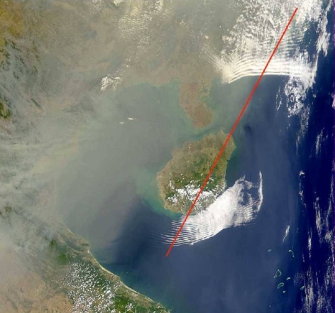
A true color SeaWiFS image taken on March 19, 1999. The ocean, in dark blue,
is the northern South China Sea. Two groups of wave clouds in white arrayed on the two sides of the
island are interpreted as signatures of
upstream and downstream solitary wave-trains generated in the real
atmosphere by topographic disturbances. The red line represents the
wind direction at 850 mb.
|