|
|
REMOTE SENSING: Rainfall
Dr. Phillip Arkin is leading research efforts on rainfall estimation. Accurate and detailed precipitation observations are crucial for understanding the global water cycle and its role in the general circulation of the atmosphere. They are also essential for studies of surface hydrology, interaction of the surface with the overlying atmosphere, and prediction of changes in water resources on time scales ranging from hourly to seasonal and annual. While precipitation is observed by surface instruments, both raingauges and radars, the spatial and temporal coverage they offer is inadequate for many applications. Thus such observations must be supplemented by estimates derived from satellite observations. Such estimates fall into two broad categories: those based on microwave observations from polar orbiting satellites, which are relatively accurate but have limited spatial and temporal sampling, and those based on infrared observations from geostationary satellites, which are significantly less accurate but provide superior spatial and temporal sampling. Methods that combine these two categories provide the best detailed depictions of precipitation over the globe, and methods for incorporating gauge observations into such combinations have made possible the construction of global analyses of precipitation suitable for describing the global water cycle. An example is provided by the products created for the Global Precipitation Climatology Project (GPCP). Current research efforts include a wide range of topics including variations in the water cycle associated with modes of climate variability, including ENSO and the North Atlantic Oscillation (NAO).
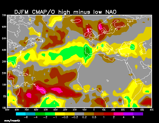 |
Variation of precipitation over the North Atlantic Ocean and adjacent land regions between extremes of the NAO. The precipitation data are derived from a combination of different satellite-derived estimates and rain gauge observations, and cover the period from January 1979 – December 2001 at monthly resolution. The figure shows that the low index phase of the NAO, characterized by weaker westerly winds across the Atlantic, is accompanied by large positive anomalies in precipitation that extend across Europe and into Asia Minor, with anomalies of opposite sign to the north and south. Such variations have clear consequences for the water cycle over land, and demonstrate the intimate connection between oceanic and continental precipitation variability. |
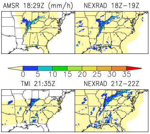
| Rainfall estimates from the National Space Development Agency of Japan's AMSR-E instrument on Aqua and the Tropical Rainfall Measuring Mission (TRMM) Microwave Imager (TMI) for a rainfall event over the eastern U.S. on June 5, 2002. By comparison to gauge-adjusted National Weather Service operational WSR 88D radar estimates, both sets are nearly unbiased. |
 |
|
|
UM Home |
Directories |
Search |
Admissions |
Calendar Maintained by James Crawford Direct questions and comments to helper@atmos.umd.edu |