Quasisynchronous observations of the Gulf Stream frontal zone with ALMAZ-1 SAR and measurements taken on board the R/V AKADEMIK VERNADSKY.
Semyon Grodsky,1,* Vladimir Kudryavtsev,1 and Andrey Ivanov.2
-
Marine Hydrophysical
Institute, Ukrainian Academy of Science, 2, Kapitanskaya str., Sevastopol,
335000, Ukraine
2. P.P.Shirshov Institute of Oceanology, 36 Nakhimovsky Pr., Moscow 177851, Russia.
Submitted
to the Global Atmosphere and Ocean System
Revised
September 1, 2000
Accepted
September 28, 2000
Note: Full resolution pictures
in PostScript format locate at:
http://www.meto.umd.edu/~senya/HTML/almaz/ps
Quasisynchronous observations of the Gulf Stream frontal zone with ALMAZ-1 SAR and measurements taken on board the R/V AKADEMIK VERNADSKY.
Grodsky,
S.A., Kudryavtsev, V.N., Ivanov, A.Yu.
Abstract.
Quasisynchronous observations of the Gulf Stream frontal zone with ALMAZ-1
Synthetic Aperture Radar (SAR) and concurrent measurements taken on board
the R/V AKADEMIK VERNADSKY are analyzed. Sea surface temperature fields
from NOAA satellites are additionally used. Space imaging was accompanied
by measurement of the standard hydrologic and meteorological parameters,
and registration of surface currents along the route of the vessel crossing
the frontal zone. Comparison of satellite and in-situ wave measurements
has shown that ALMAZ-1 SAR displays the basic parameters of long waves
(wavelength and orientation) rather precisely. Based on 2-D radar image
spectra the effects of wave refraction are investigated. The surveys were
carried out at moderate westerly winds when the waves evolved in the along
current direction. In these conditions, the effects of wave reflection
produced the zones of wave concentration and wave "shadow". Based on synchronous
satellite and in-situ measurements, the wave-radar image modulation
transfer function (MTF) were estimated and used to retrieve wave elevation
variance from radar image spectra. The estimations of wave energy changes
corresponded qualitatively to spatial variations in the ship vertical displacement
variance. Linear features oriented along the Gulf Stream were revealed
in SAR images. They originate from wave-current interaction and short wave
damping in areas of sargassum accumulations (convergence).
Keywords:
wave, SAR, wave refraction, the Gulf Stream signature
1.
INTRODUCTION.
Ocean
mesoscale fronts, are areas of intensive energy and substance exchange
between ocean and atmosphere, influence on biological processes, and have
appreciable signatures on the sea surface. The ability of observing them
by spaceborn Synthetic Aperture Radar (SAR), possessing high spatial resolution,
was shown for the first time with SEASAT SAR (see for example, Beal
et al. 1981). These observations and later ones carried out with ERS-1
SAR (Johannessen et al., 1994; Nilsson et al., 1995; Beal
et al., 1997) and KOSMOS-1500 RAR (Mitnik et al., 1989) have
shown that these radars provide an opportunity to investigate thermal structure
of the frontal zones and detect current boundaries.
Current
variations across the frontal zones may influence surface waves significantly.
Theory predicts (see e.g. Kenyon, 1971) the most interesting effects:
wave reflection by a current and waveguide-like propagation of the trapped
wave towards the current. Trapped wave concentration in a jet can cause
a danger to navigation (Gutshabash and Lavrenov, 1986). Wave-current
interaction forces spatial variation of wave energy. This was explicitly
shown by Liu et al. (1994) from empirical analysis of wave ray refraction
patterns inferred from ERS-1 SAR image received over an oceanic eddy and
model calculations.
Spaceborn
SAR resolves long surface waves allowing investigation of wave refraction
on current inhomogeneuties (Barnett et al., 1989; Sheres et al.,
1985). Wave evolution on the Gulf Stream and wave refraction on a warm
core ring were observed by SEASAT SAR (Beal et al., 1986; Mapp
et al., 1983). The SIR-B data were used to research the trapped waves
in the Agulhas current (Irvine and Tilley, 1988), and wave behavior
in the Circumpolar area (Barnett et al., 1989). However, these data
were not supported by synchronous measurements of currents.
One
of the most complete observations of wave evolution was performed by Kudryavtsev
et al. (1995) on board the R/V AKADEMIK VERNADSKY, which crossed the
Gulf Stream frontal zone repeatedly in August - September 1991. In this
experiment radar wave observations, accompanied by registration of surface
currents and the Marine Atmospheric Boundary Layer parameters, have been
performed in conditions, which allowed the most prominent peculiarities
of wave-current interaction, including wave reflection by current and wave
trapping by opposing jet to be revealed. Shipboard measurements were supplemented
by quasisynchronous satellite ALMAZ-1 SAR imaging of the experimental area.
This
paper is aimed at the analysis of the Gulf Stream radar signatures and
wave behavior on a shear current based on the ALMAZ-1 SAR data and the
R/V AKADEMIK VERNADSKY measurements. Experiments were performed at the
end of August and beginning of September 1991 as a part of the OKEAN-I
field program (Viter et al., 1993).
2.
GENERAL DESCRIPTION OF THE EXPERIMENT.
The
Gulf Stream radar surveys were carried out on August 23, 28, 29, and on
September 7, 8, 1991. The study is limited to analysis of data collected
on August 28, 29 and September 7. These days the surface waves were high
enough to be resolved by a SAR, and in-situ ship measurements were
collected. The experiments were performed under westerly wind with speed
5 m/s<W<15 m/s.
The
Gulf Stream temperature front position was determined from AVHRR NOAA data
received by ship station (the Automatic Picture Transmission Regime). The
surface measurements were carried out from a moving vessel, which crossed
the current in a direction perpendicular to the front with measurements
of the oceanic and atmospheric boundary layer parameters along a route
located within an image swath. In-situ wave records were carried
out on August 28 and September 7 at the time of satellite overpass by a
one-component drifting buoy accelerometer. A ship measuring complex described
by Kudryavtsev et al. (1995) allowed registration of: sea surface
temperature, Tw, air temperature, Ta,
wind velocity, W, surface current, U, whitecap coverage,
Q,
vertical displacement of the vessel (when moving) and wave vertical acceleration
(when the vessel was drifting). The current speed was registered by the
towed Electromagnetic Kinetograph (EK), which measures flow component perpendicular
to ship heading. To estimate surface current, U, the assumption
that the Gulf Stream is a flat parallel jet directed along the
Tw
front was used.
Radar
surveys were planned so that the images covered both northern and southern
sides of current. It has allowed analysis of a radar fingerprint of the
Gulf Stream front and investigation of spatial non-homogeneity of waves
caused by their interaction with the current.
Table
1 presents the parameters of images collected by ALMAZ-1 SAR during the
experiment.
Table
1. List of ALMAZ-1 SAR images and the parameters of environmental conditions.
|
Date, 1991.
|
|
|
|
|
Orbit
|
|
|
|
|
Time, UTC
|
|
|
|
|
Distance R,
km
|
|
|
|
|
Incident angle, deg.
|
|
|
|
|
Image dimension,
km
|
|
|
|
|
Wind (at the moment
of imaging):
speed, m/s
azimuth (from), deg.
|
10 260 |
8 280 |
12 290 |
|
Wave information
wavelength, m
azimuth, deg
wave displacement
variance, m2
|
150; 150 20¸50;
80¸90 - |
150; 80¸110 135; 80¸110 0.26 |
140¸150 130¸140 0.58 |
3.
CHARACTERISTICS OF ALMAZ-1 SAR AND DATA PROCESSING PROCEDURE.
The
main parameters of ALMAZ-1 SAR are summarized by
Alpers et al. (1994)
and briefly in Table 2.
Table
2. Parameters of ALMAZ-1 SAR
|
Active period
|
91.03.31 - 92.10.17
|
|
Orbit altitude
|
270÷380 km
|
|
Orbit inclination
|
72.7°
|
|
Wavelength
|
9.6 cm
|
|
Ground resolution
|
10¸15
m
|
|
Incidence angle
|
varying, 250¸600
|
|
Swath width at different
incidence angles
|
35¸55
km
|
|
Polarization
|
horizontal (HH)
|
|
SAR integration time
|
0.3 s
|
SAR
spatial resolution allows observation of long surface waves. To investigate
them, 2-D radar image spectra were calculated. Each spectrum represents
the squared modulus of the FFT transform of radiance distribution within
an elementary 128x128 points image subscene
(pixel size 10x10m). Final spectral estimates were smoothed over a frame
containing 7x7=49 elementary subscenes
(frame size 9x9km) with the subsequent smoothing on squares 3x3 in k-space,
that provided ~900 degrees of freedom.
The
image spectrum is related to wave one by the spatial wave-radar Modulation
Transfer Function (MTF), which is not known a priori. It consists
of three basic terms (Alpers et al., 1981): geometrical, Mt,
hydrodynamic, Mh, and an additional term due to velocity bunching
effect, Mv. The last one is the most interesting from the viewpoint
of SAR imaging. It is caused by azimuthal displacement Dx in
the image plane of a moving target, which is proportional to a projection
of its speed to inclined range Dx=(R/V)vR,
where V is the satellite ground velocity. At vR~1m/s
the value Dx~45
m is comparable to the length of a registered wave l.
If the wavelength projection on the direction of flight lx<![]() =4Dx,
the wave imaging is essentially nonlinear. An estimation of
=4Dx,
the wave imaging is essentially nonlinear. An estimation of ![]() for
ALMAZ-1 SAR equals
for
ALMAZ-1 SAR equals ![]() 100
m at a wave steepness of
100
m at a wave steepness of ![]() =0.05.
=0.05.
The
velocity bunching mechanism allows imaging of azimuth wave component restricting
(at the same time) SAR resolution in the flight direction. According to
Hassellmann
et al. (1985), the total MSR displacement, dx,
of the image is formed by: 1) statistical contribution of the orbital velocities
of intermediate scale waves within SAR resolution cell, dxi,
2) time changes (within integration interval) in orbital velocities of
waves resolved by SAR, dxl.
They can be estimated as:
 ,(2)
,(2)4.
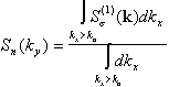
COMPARISON OF RADAR AND IN-SITU MEASUREMENTS OF WAVE SPECTRA.
Synchronous
with radar imaging in-situ wave records were obtained with a buoy
accelerometer on August 29 and September 7. On August 29, wave measurements
were taken at point E (see Figure 5 below), and in the experiment
September 7 - in a vicinity of point #12 (see Figure 8). Figures
2a and 2b display wavenumber spectra S(k) calculated
from surface elevation frequency spectra using the deep-water linear wave
dispersion relation. These spectra satisfy a condition ![]() where
<z2>
is the wave elevation variance. Figure 2 also presents radar image omnidirectional
spectra normalized by the square of an average radar signal: Ss(k)/<s>2.
They are obtained by integration over azimuth j
of 2-D radar image spectra
where
<z2>
is the wave elevation variance. Figure 2 also presents radar image omnidirectional
spectra normalized by the square of an average radar signal: Ss(k)/<s>2.
They are obtained by integration over azimuth j
of 2-D radar image spectra ![]() .
Referring to Figure
2a and 2b, we find that the radar spectrum reproduces satisfactorily
the spectral shape of the energy containing waves and the spectral peak
position on the wavenumber axis.
.
Referring to Figure
2a and 2b, we find that the radar spectrum reproduces satisfactorily
the spectral shape of the energy containing waves and the spectral peak
position on the wavenumber axis.
Figure
2c illustrates the magnitude of wave-radar MTF M(k), which relates
omnidirectional radar image spectrum and in-situ wave spectrum:
5.
RADAR OBSERVATIONS OF WAVE SPECTRA EVOLUTION
We
shall consider variability of waves in the Gulf Stream frontal zone on
the basis of 2-D SAR spectra and wave ray calculation. A simple technique
utilizing the wave ray approach is a valuable tool that provides an insight
into the physics of wave-current interaction and helps in understanding
the wave variability in the areas of non-uniform currents (see e.g.
Vachon et al., 1995). The accuracy of wave ray calculations is limited
(as a rule) by an insufficient knowledge of the spatial picture of surface
currents. Preliminary interpretation of the data presented in this paper
as well as the analysis of sensitivity of the wave ray pattern to accuracy
of the current field are presented in Grodskii et al. (1992, 1996a,
b) and Grodsky et al. (1996c).
It has been shown that the wave pattern is influenced sufficiently by the
mutual orientation of waves and surface flow and by the value of maximal
current speed. The direction of current is known indirectly through the
SST front configuration. The crosscurrent speed profile comes from the
only one section along the ship route. It is extrapolated assuming the
flat parallel flow model following the shape of the SST front. Accounting
for possible inaccuracy of the spatially extrapolated surface flow field,
we shall further consider the results of wave ray calculations only as
a proxy showing that the observed wave situations can potentially exist.
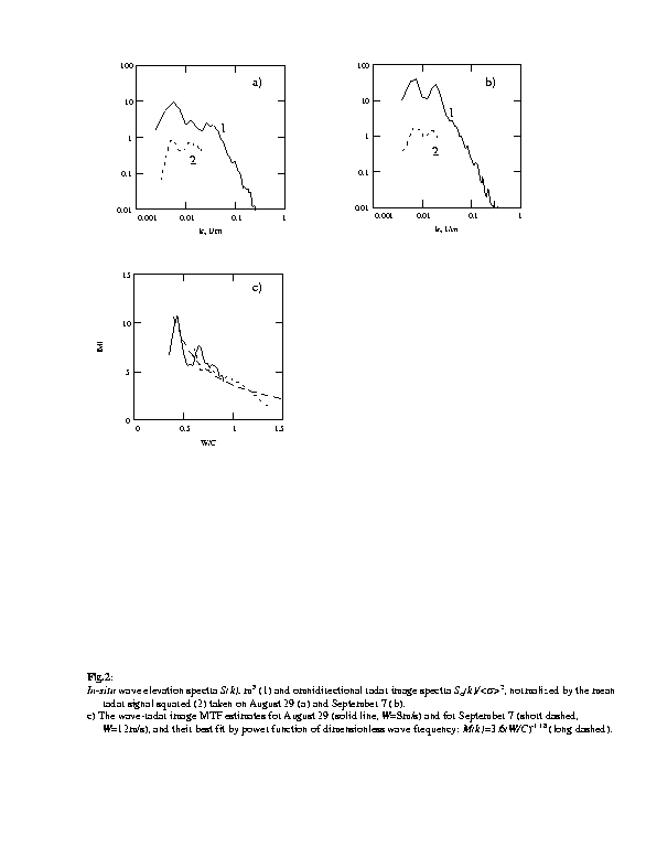
Experiment
August 28.Figure
3 shows the scheme of the experiment as a Sea Surface Temperature (SST)
map with SAR image (smoothed to 1 km resolution) overlaid. The Gulf Stream
thermal front separates colder shelf waters (240C, dark) and
warm waters of the current (280-290C, bright). The
location of a zone of the maximum temperature gradients coincides rather
precisely with a zone of maximum current speed. General parameters of this
and other experiments are summarized in Table 1.
The
in-situ
measurements were taken along a trajectory of the vessel crossing the current.
At the moment of imaging the ship was at a point with coordinates 39.40N,
63.60W. According to visual observations from the ship, on the southern
side of the Gulf Stream there was a mixed sea consisting of several wave
systems traveling in a sector between the east and the north directions.
On the northern side only one system of the NNE direction existed. It agrees
with radar image subscenes
(size 256x256 pixels, resolution 10m) shown in the lower panel of Figure
3 and presenting an enhanced image structure at points #4 and #22.
They were obtained by direct and inverse FFT calculations with eliminating
of harmonics lying below 40% of the maximum energy level. The wave field
south of the jet (point #22) consists of two systems, and on the northern
side of the Gulf Stream (point #4) only one wave mode exists. The two systems
have wavelength ~150m, and their orientation is shown by arrows.
The
spectra presented in Figure
3 illustrate the basic peculiarities of the wave field. It shows the
essential changes of character of the waves on the northern side of the
Gulf Stream (points 8¼12)
in comparison to the southern one (points 16¼22).
Analyzing the spectral shape, one can select two wave systems. The spectral
peaks corresponding to these wave systems are marked with symbols A
and
B
in Figure
3 (right panel). On the northern side of the current (points 8¼12),
the radar spectra have a single peak (system A). On its southern
side (points 16¼22),
the spectrum's angular width increases due to the presence of two wave
systems. At the same time, the spectra have higher energy level
on the northern side of the Gulf Stream, which indicates wave concentration
in this part of the current.
The
local maximum A corresponds to waves crossing the current and is
observed on all spectra. The maximum B is registered only on the
southern side and can be explained as waves reflected by the Gulf Stream.
This hypothesis is confirmed by a ray calculation performed for an uniform
wave field south off the Gulf Stream with a wave vector corresponding to
system A (see Figure
4a). It shows that due to refraction the background wave field is separated
into two systems,
A and B, depending on the local incidence
angle. In a "southern" part of the radar image the trajectories cross,
which corresponds to a superposition of waves in image subscene
22 of Figure
3. Only system
A penetrates to the northern side of the current,
where SAR has registered an unimodal wave field at point 4. The reflection
of waves occurs to the west of the area imaged by SAR where the local incidence
angle is greater owing to a curve in the jet.
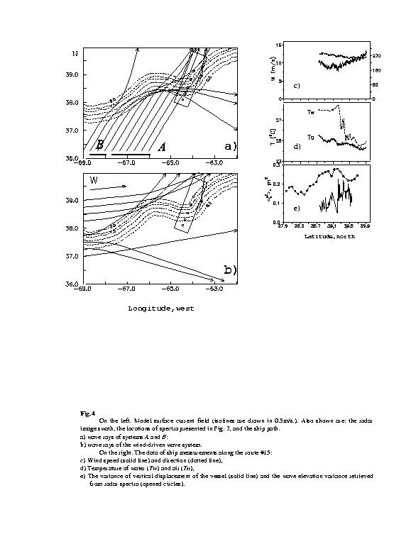
Wave
ray calculations presented in Figure
4b explain the absence of a wind wave system on the radar image. Really,
the waves oriented along the wind direction are deviated by the current
forming a "shadow" area within the image swath. At the same time, locally
generated short wind waves would probably not be resolved by radar.
The
data of ship measurements along route #15 are also presented in Figure
4 (see Figure
3 for ship path location). The variance of vertical displacement of
the vessel (indirectly reflecting wave elevation variance <z2>)
grows on the northern side of the current (see Figures
4e and 4d). Wave variance retrieved from the radar spectra has
a similar tendency. The observable changes in wave energy are
not connected to the wind (Figure
4c) and, probably, are a result of wave interaction with a non-uniform
current. The growth of wave energy on the northern side of the Gulf Stream
is explained qualitatively by local concentration of waves of system A
(see Figure
4a).
Experiment
August 29
was carried out at meteorological conditions similar to the previous experiment
at a moderate westerly wind of W=5m/s to 11 m/s (see Table 1). The
vessel trajectory is shown in Figure 5 on a background of the SST map received
from NOAA satellite. The observable thermal structure is less pronounced
(in comparison with the previous experiment), which is caused by the influence
of continuous and partial cloudiness (C). The Gulf Stream temperature
front (T) divides colder shelf water (Tw=250C)
and rather warm stream waters (Tw=280C). Figure
5 shows the SAR image smoothed within the squares 250 m x 250 m. The
upper panel of Figure 5 illustrates the general structure of the Tw
field with the thermal front marked by a solid line.
The
sample of 2-D radar spectra reflects the basic characteristics of wave
variability. On the northern periphery of the Gulf Steam two wave systems
are observed, to which the spectral maxima A and B correspond.
The waves of system A (l~150m)
propagating in the SE direction are registered on all spectra and cross
the current without reflection. Spatial non-uniformity of the wave field
is formed basically by system B. Characteristic wavelength of these
waves (80 m <? <110 m) is smaller than that of system A.
They were registered only on the northern periphery of the Gulf Stream
(points 10¼4
of Figure
5) and were not observed in the area of stronger current (points 3¼1).
The
peculiarities of waves are qualitatively explained by wave packet kinematics
on non-uniform current. Figure
6 shows model surface current field and wave rays for system B
(panel a) and system A (panel b). Wave rays of system B are
calculated for a spatially uniform background wave field oriented in the
along-wind direction. Due to refraction on the anticyclonic meander located
at 660 W, the wind-wave system divides into two sub-systems
deviating accordingly to the north and to the south of the jet. However,
unlike in the previous experiment, only the southern part of the radar
image appears in a zone of "shadow" where the energy of the wind waves
is much lower than the background. As a result, the wind wave system does
not stand out against system A in radar spectra at points 3¼1
of Figure 5. Wave rays of system A (see Figure
6b) expose weaker influence of the current that is caused by smaller
incidence angle and greater wavelength as compared to system B.
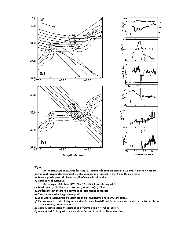
The
concentration of waves on the northern periphery of the Gulf Stream is
proved by an increase in the ship?s vertical displacement variance and
agrees with spatial changes of wave energy inferred from the SAR spectra
(see Figure
6g). The growth of energy is caused by spatial concentration of waves
of system B. It is confirmed by the wave spectra S(k)
(see
Figure
5) retrieved from the SAR image at points #1 and #10 by applying the
empirical MTF presented in Figure
2c.
The
Experiment on September 7
was carried out at moderate westerly wind 11 m/s <W
<15 m/s. Unlike the previous days, the Tw field
has complex character, caused by instability of the jet. As follows from
Figure
7, the radar image covers a zone of an evolving cyclonic Gulf Stream
ring. Thus, its northern part appears on a forward front of the warm water?s
"tongue".
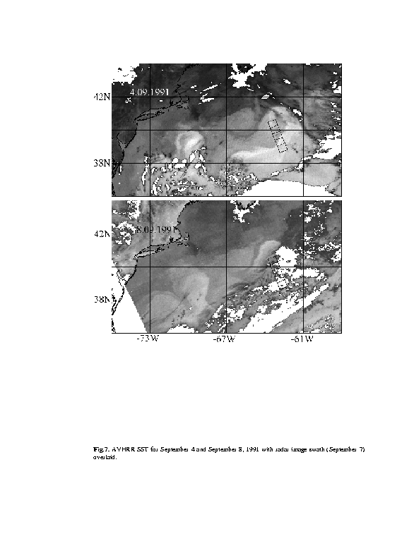
The
experimental scheme is shown in Figure
8 as a composition of the SAR image and the SST field for September
4. To estimate possible displacement of the front during the 3 days separating
the times of radar and SST surveys, the coordinates of points are put in
at which the vessel crossed the thermal front on September 6 and 7. Referring
to Figure 8, we find only small changes in the spatial location of the
Gulf Stream temperature front that allows use of its configuration recorded
on September 4 (see Figure 7) to analyze data collected on September 7.
At the same time, one can expect that the earlier hypothesis of a constant
cross current speed profile will not be valid in conditions of a complex
configuration of the front, connected with flow instability. Nevertheless,
we have performed wave calculations with the model field U built
using the above assumption.
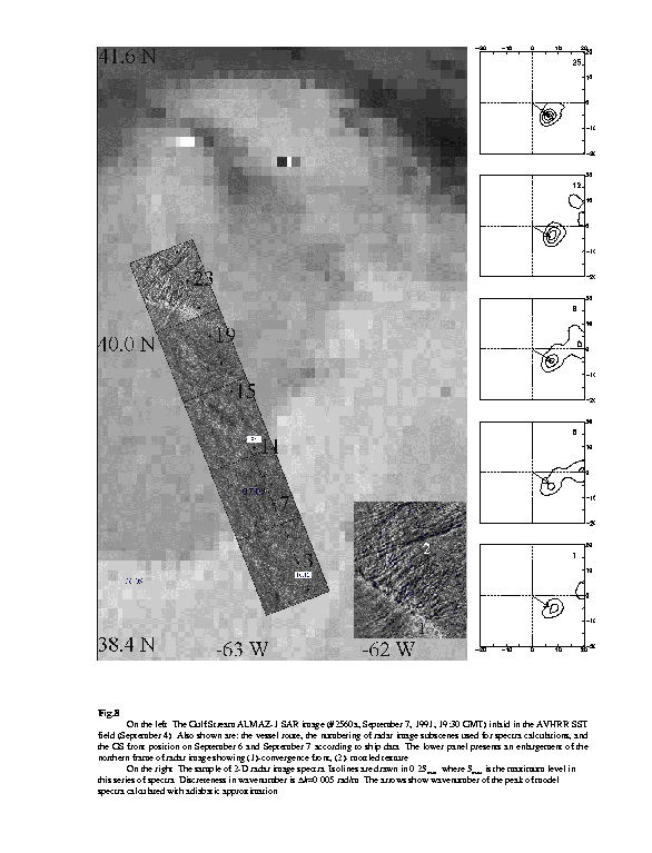
All
radar spectra shown in Figure 8 have local maximum corresponding to waves
propagating in the SE direction. They cross the current, keeping practically
constant wavelength (~150m) and orientation (azimuth~1350),
that agrees with a picture of wave rays (see Figure
9a), which look like quasi-parallel lines on the whole width of the
processing area. They result from mutual orientation of waves and current,
when the rays penetrate into a jet practically along the front normal,
and refraction effects are minimum.
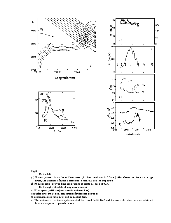
At
the same time, the wave energy retrieved from the radar spectra possesses
local maximum in the area of maximal current (Figure
9f and 9d) that agrees in general with spatial changes in the variance
of vertical displacement of the vessel (Figure 9f). Outside the Gulf Stream
and on its northern side (see points 25¼8
of Figure
8) the background waves evolving in the SE direction have approximately
constant spectral peak level (Figure 9b). Further, in a southern direction
(between points #8 and #1, see Figure 8) the energy of these waves falls,
which is illustrated with the wave spectrum S(k) at point #1 (Figure
9b). This effect is not explained with a simplified surface current scheme
as a flat parallel jet following the configuration of the thermal front.
6.
RADAR SURFACE CURRENT SIGNATURES.
The
analysis of the SAR images has allowed us reveal a number of structures
connected to the sharp current gradients in the Gulf Stream frontal zone.
We were limited to analysis of phenomena of spatial scales of a few kilometers.
The specificity of ALMAZ-1 SAR operation (see Section 3) did not allow
us to register radar fingerprints of larger scale phenomena, which were
observed with ERS-1 SAR (see e.g. Beal et al., 1997).
The
Experiment August 28.
Figure
3 shows an enlargement of the southern part of the radar image, which
reveals a contrast boundary oriented parallel to the temperature front
and separating the areas with differing backscatter level. Note a bright
linear structure located to the south of the boundary mentioned above at
a distance of ~5km and parallel to it. Similar structures were frequently
observed visually and by remote technique at weak and moderate winds in
the Gulf Stream area (see e.g. Marmorino et al., 1994;
Beal et
al., 1997 and literature cited therein) in close vicinity of current
convergence lines. Under certain conditions, the waves experience intensification
here, cause sea surface roughness increase and radar signal growth.
The
Experiment August 29.
Let us consider in more detail the observations of linear structures based
on data of August 29, when the ship measurements were carried out within
the image swath (see Figure
5). The SAR image presents two strips having negative (A) and
varying (B) contrast. They are oriented parallel to the thermal
front, and strip B perfectly coincides with its location. The bottom
panel of Figure 5 shows an enlarged view of the line features. Within line
A
the level of radar backscatter is lower than the background one. At the
same time, line B possesses varying radar backscatter. Its western
part looks as a bright feature, while the eastern part has mostly lower
brightness as compared to background one.
For
interpretation of these structures, we use the data of ship measurements
(Figure 6)
collected during several hours in advance of the satellite survey. Figure
6c illustrates the variability of wind speed and direction. At the moment
of imaging, the vessel was at point E (see Figure
5) where westerly wind of W = 8 m/s was observed. Figure 6d
presents crosscurrent flow profile, and centers of image subscenes
used for radar spectra calculations. Also marked are the points where the
vessel crossed the strips A and B, respectively. The strips
are located at the northern side of the current profile. Their positions
do not correlate unequivocally to spatial variations in cross current velocity
shear (Figure 6e), which have doubled local extremum in close vicinity
of line B and no peculiarities corresponding to line A. It
indicates on the fact that the origin of the strips is also connected to
structure of the cross current circulation, which can?t be estimated using
EK measuring only one flow component perpendicular to ship?s heading. At
the crossing by the vessel of strips A and B, slicks and
sargassum accumulations were visually observed indirectly indicating
current convergence. These data do not yield to quantitative interpretation;
however, we can note that the maximum concentration was observed near strip
A.
Sargassum
accumulations aligned with current boundaries are characteristic of the
Gulf Stream frontal zone (Stommel, 1960). That is why, the sea surface
brightness may serve as an objective indicator of current convergence in
the Sargasso Sea. As such an indicator we used the measurements of wave
breaking intensity Q obtained by TV camera. It can be made, since
sargassum as imaged by the camera produces signal spikes similar to those
from bright whitecaps, and sargassum accumulations are registered as locally
bright objects. In Figure 6h the measurements of Q are normalized
with a background dependence Qo~au*3
(which is proportional to air friction velocity cubed (Wu, 1988))
to exclude variations caused by wind speed and whitecap changes. Sargassum
strips are expressed as local maxima in Q/Qo (see Figure
6h), and their positions correlate with lines A and B.
The
expected fingerprints of the convergence structures are determined by wind
speed. At a weak wind, the effect of pollution and surface active material
accumulations predominates. That results in slicks with reduced radar backscatter.
With wind growth, the surface films are destroyed, and the determining
factor becomes concentration of wave energy in convergence zones, that
forms bright structures due to roughness increase. The expected radar signature
of the current convergence is to be of the same sign as that due to slicks.
If convergence acts along with crosscurrent velocity shear, the resulting
radar fingerprint can be more complicated.
Lyzenga
(1991) has proposed a model of radar contrasts of the ocean fronts based
on a local balance approach (Alpers, 1985) for Bragg ripple. If
flow parameters vary only in the direction normal to the front, the magnitude
and sign of the contrast depends on mutual orientation of radar look direction
with respect to the front line, and also on the relation between divU
and rotU (Johannessen et al., 1996). However, the expected
contrasts of centimetric wind waves are insignificant. The real radar contrasts
of the fronts should be determined by a wider range of wind waves forming
the "roughness" of the sea surface (Makin et el., 1995). Thus, the
energy of Bragg ripple follows changes of wind resulting from the Marine
Atmospheric Boundary Layer reaction to spatial changes in the underlying
surface parameters (Kudryavtsev et al., 1997). In a general case,
the radar contrasts will depend on wind velocity, radar orientation, the
components of current shear tensor, and surface film concentration.
Distinctions
in radar signatures of structures A and B are worth noting.
Distance between the strips is a few kilometers, so, they were observed
(probably) in similar surface wind conditions. The measurements of Q
provide estimates of the current convergence in the area of the strips,
to probably be stronger for the strip A zone.
At the same time, strong crosscurrent shear (see Figure
6e) is registered near line B, which is absent in vicinity of
structure A. Due to line B curving, the waves traveling in
the wind direction experience different changes in surface current in the
western and in the eastern parts of line B. In the western part,
wind waves (directed eastward) cross a current shear zone starting from
its southern part toward the northern one, and are influenced by decrease
in the current magnitude, which acts to increase wave energy. Conversely,
in the eastern part of line B, wind-driven waves are influenced
by a current increase, which results in wave damping. The above mechanism
may be a reason of varying radar signal contrast along line B. Thus,
it is possible to conclude, that the negative radar contrast of strip A
is due to slick, and the image of the linear feature B is determined
by the combined action of floating substances, accumulated in a convergence
zone and wave-current shear interaction.
The
experiment September 7.
Wind and wave strengthening destroys linear structures, which are not visible
on the SAR image collected on September 7 (see Figure
8). Its basic peculiarity are contrast structures of the "northern"
frame located in a zone of the forward front of a warm water "tongue" of
the Gulf Stream cyclonic disturbance (see Figures
7 and 8). Its development is accompanied, probably, by the formation
of a convergence zone caused by warm water advection toward the slowly
moving shelf water. The local amplification of waves owing to convergence
action forms a bright radar signature oriented along the front (1) in the
NW-SE direction (see enlargement to Figure 8). To the north of it, the
radar detected wave-like disturbances (2), oriented perpendicularly to
the front. Characteristic distance between the strips is a few kilometers.
Probably, they result from intensive interaction between warm and cold
waters, displaying an unstable current field in an evolving ring accompanied
by Internal Wave generation. We shall note that to the south of front where,
probably, the currents are small these disturbances are absent. Similar
structures in a warm ring of the Gulf Stream (named "mottled texture")
were illustrated earlier by Lichy et al. (1981) with SEASAT SAR.
7.
SUMMARY.
Within
the framework of the OKEAN-I program the experiments on quasi-synchronous
observations of the Gulf Stream frontal zone are performed with ALMAZ-1
SAR and from the R/V AKADEMIK VERNADSKY.
The
low orbiting space vehicle, ALMAZ-1, provided rather small values of R/V
parameter, therefore the contribution of SAR nonlinear wave imaging effects
were minimum. The comparison of wave parameters obtained by the spectral
analysis of SAR images with in-situ measurements of waves has shown
good conformity. That allows us to determine basic kinematic characteristic:
wavelength and wave orientation by radar scene FFT processing. Based on
two case observations the wave-radar image MTF is estimated. Its modulus
is inversely proportional to wave frequency and decreases with wind speed.
The
theory of interaction with jet current (Kenyon, 1971) predicts an
opportunity for wave reflection and trapping by a flow. These effects were
studied in the third generation model by Holthuijsen and Tolman
(1991); however, the real behavior of waves in a zone of large-scale currents
requires additional investigations. Using spaceborn SAR, we observed wave
reflection by current, which appeared as a combined effect of the current
shear and upstream curving of the Gulf Stream. This forms local areas of
wave "shadow" and intensification. The concentration of waves at the current
boundaries due to a superposition of several systems produces a danger
to navigation because of energy increase and significant broadening of
the angular spectrum (James, 1974). The operative control of such
situations outside of dependence on weather conditions has practical interest
and is possible only with the help of SAR.
The
convergence strips at the boundaries of water masses are characteristic
of the ocean fronts. Here a number of processes forming radar contrasts
of different sign take place. Surface films and pollution accumulation
suppresses centimetric wind ripples that are responsible for backscattering
of radiowaves. Together with this, wave energy is concentrated in convergence
zones with possible occurrence of stochastic wave strips siome (Uda,
1938; James, 1974). The sea surface roughness growth induced by
waves steepening and chaotic breaking increases the radar signal, and after
a bright strip occurrence of a dark one is possible. The relative contribution
of these two processes depends on the wind speed, surface film characteristics,
and current non-uniformity. Probably, at a weak to moderate wind W <
8 m/s the film effect is important, and the convergence strip has low radar
signal. With wind increase above 10 m/s the sea surface films are destroyed,
and the convergence zones get bright radar signature. For a fresh wind
(probably stronger than 15 m/s) the efficiency of both mechanisms falls,
and the waves, forming the sea surface roughness, are in balance with the
local wind.
Comparison
of satellite and surface data has shown that linear structures oriented
along a thermal front manifested the zones of local maxima in surface current
changes. The convergence strip (identified from on board of the vessel
by sargassum accumulations) had low signal on the radar scene received
at W=8m/s. At a distance of several kilometers from it, the area
of sargassum enrichment and significant local cross current shift was registered,
which displayed as a structure with varying radar signal. The value and
sign of radar backscatter variation depends on the mutual orientation of
the waves, current gradients, and radar look direction. On a radar image
obtained at W=12 m/s the linear structures were not observed. Here
the bright area was registered to be coinciding with a probable convergence
front caused by warm waters advecting to a zone of slowly moving shelf
waters. Also occurring here were the wave-like structures orthogonal to
the front. The nature of these ?wavy? signatures is not sufficiently clear
and requires additional investigations.
Acknowledgments.
The
field program was realized with financial support from the Fishing Ministry
of Russia. This investigation was supported in part by the Grant UD9200
funded jointly by the Ukrainian Government and International Science Foundation.
The authors appreciate the contribution of Dr. Pavel Shirokov (Center Almaz,
NPO Mashinostroenie), Dr. Gennady Korotaev of Marine Hydrophysical Institute
(MHI), Ukranian Academy of Sciences, Dr. Yury Trokhimovsky of Space Research
Institute (SRI), Russian Academy of Sciences and Dr. Andrey Smirnov of
SRI (now at NOAA ETL) in organization and coordination of the experiment.
Dr. Alexandr Babanin of MHI (now at School of Civil Engineering UNSW, Canberra)
kindly provided the data of in-situ wave records. The data on whitecap
coverage were provided by Dr. Vladimir Dulov of MHI. Authors acknowledge
valuable comments of Dr. Kristina Katsaros and anonymous reviewer.
REFERENCES.
Alpers,
W., D.B. Ross, and C.L. Rufenach. (1981), ?On the detectability of ocean
surface waves by real and synthetic aperture radar?,J.
Geoph. Res., 86, C7,
p.6481-6498.
Alpers,
W.R. (1985), ?Theory of radar imaging of internal waves?, Nature, 314,
p.245-247.
Alpers,
W., K Bruning, A. Wilde, V.S. Etkin, K.Ts Litovchenko, A.Yu. Ivanov, and
V.V. Zaitsev (1994), "Sea wave imaging by the Synthetic Aperture Radars
(Comparative analysis of data, received ALMAZ-1 and ERS-1 SAR) ", Sov.
J. Rem. Sens., 6, p.83-95.
Barnett,
T.P., F. Kelley, and B. Holt (1989), ?Estimation of the two-dimensional
ocean current shear field with a Synthetic aperture radar?, J. Geoph.
Res., 94, C11, p.16.087-16.095.
Beal,
R.C., I. Katz, and P. De Leonibus (Eds) (1981), ?Spaceborne SAR for oceanography?,
The Johns Hopkins University Press, 213 pp.
Beal,
R.C., T.W. Gerling, D.E. Irvine, F.M. Monaldo, and D.G. Tilley (1986),
?Spatial variations of ocean wave directional spectra from SEASAT SAR?,
J.
Geoph. Res., 91, C2, p.2433-2449.
Beal,
R.C., V.N. Kudryavtsev, D.R. Thompson, S.A. Grodsky, D.G. Tilley, V.A.
Dulov, and H.C. Graber (1997), "The influence of the marine atmospheric
boundary layer on ERS-1 synthetic aperture radar imagery of the Gulf Stream",
J.
Geoph. Res., 102, C3, p.5799-5814, (in Russian).
Grodskii,
S.A., V.A. Dulov, and V.N. Kudryavtsev (1992), 'Observation of surface
wave refraction on the Gulf Stream', Dokl. Akad.
Nauk SSSR,
322,
6, p.1162-1167.
Grodskii,
S.A., V.N. Kudryavtsev, A.Yu. Ivanov, V.V. Zaitsev, and D.M. Solov?ev (1996a),
"
Interaction of surface waves with the Gulf Stream according to ALMAZ-1
SAR data", Issledovanie
Zemli iz Kosmosa., 3, p.38-47, (in Russian).
Grodskii,
S.A., V.N. Kudryavtsev, and A.Yu Ivanov (1996b), "Study
of the Gulf Stream frontal zone using the ALMAZ-1 SAR and in-situ ship
measurements", Issledovanie
Zemli iz Kosmosa, 6, p.59-70, (in Russian).
Grodsky,
S.A., V.N. Kudryavtsev, A.Yu. Ivanov, V.V. Zaitsev, and D.M. Solov?ev (1996c),
?Surface Wave Observation in the Gulf Stream Area Using ALMAZ-1
SAR?, IGARSS?96, Lincoln, NB, USA, 27-31 May 1996, v.IV, p.1971-1973.
Gutshabash,
E,Sh., and I.V. Lavrenov (1986), "Swell transformation on Agulhas current",
Russian
Ac. Sci, Izvestija,
Atmos. Oceanic Phys.., 22,
6, p.643-648.
Hassellmann,
K., R.K. Raney, W.J. Plant, W. Alpers, R.A. Shuchman, D.R. Lyzenga, C.L.
Rufenach, and M.J. Tucker (1985), ?Theory of Synthetic Aperture Radar Ocean
Imaging: A MARSEN View?, J. Geoph. Res., 90, C3, p.4659-4686.
Holthuijsen,
L.H., and H.L. Tolman (1991), ?Effects of the Gulf Stream on ocean waves?,
J.
Geoph. Res., 96, C17, p.12.755-12.771.
Irvine,
D.E., and D.G. Tilley (1988), ?Ocean wave directional spectra and wave
-current interaction from shuttle imaging radar-B synthetic aperture radar?,
J.
Geoph. Res,
93, C12, p.15.389-15.401.
James,
R.W. (1974), ?Dangerous waves along the North Wall of the Gulf Stream?,
Mariners Weather Log., 18, p.363-366.
Johannessen,
J.A., P.W. Vachon and O.M. Johannessen (1994), ?ERS-1 SAR imaging of marine
boundary layer processes?, Earth Obs. Quart., 46, p.1-5.
Johannessen,
J.A., R.A. Shuchman, G. Digranes, D.R. Lyzenga, C. Wackerman, O.M. Johannessen,
and P.W. Vachon (1996), ?Coastal ocean fronts and eddies imaged with ERS-1
synthetic aperture radar?, J. Geoph. Res., 101, C3, p.6651-6667.
Kenyon,
K.E. (1971), ?Wave refraction in ocean currents?, Deep Sea Res.,
18,
p.1023-1034.
Kudryavtsev,
V.N., S.A. Grodsky, V.A. Dulov, and A.N. Bol'shakov (1995), ?Observation
of wind wave field in the Gulf Stream frontal zone?, J. Geoph. Res.,
100,
C10, p.20,715-20,727.
Kudryavtsev,
V.N., C. Mastenbroek, and V.K. Makin (1997), ?Modulation of wind ripples
by long surface waves via the air flow: a feed-back mechanism?, Bound.
Layer Meteor., 83, p.99-116.
Lichy,
D.E., M.G. Mattie, and L.J. Mancicni (1981), ?Tracking of a warm water
ring?, in ?Spaceborne SAR for oceanography?, Eds. Beal, R.C., I. Katz,
and P. De Leonibus, 1981, The Johns Hopkins University Press, p.171-184.
Liu,
A.K., C.I. Peng, and J.D. Schumacher (1994), ?Wave-current interaction
study in the Gulf of Alaska for detection of eddies by syhthetic-aperture
radar?, J. Geoph. Res., 99, C5, p.10,075-10,085.
Lyzenga,
D.R. (1991), ?Interaction of short surface and electromagnetic waves with
ocean fronts?, J. Geoph. Res., 96, p.10,765-10,772.
Makin,
V.K., V.N. Kudryavtsev, and C. Mastenbroek (1995), 'Drag of the sea surface',
Bound.
Layer Met., 73, p. 159-182.
Mapp,
G.R., C.S. Welsh, and J.C. Munday (1985), ?Wave refraction by warm core
rings?, J. Geoph. Res., 90, C4, p.7153-7162.
Marmorino,
G.O., R.W. Jansen, G.R. Valenzuela, C.L. Trump, J.S. Lee, and J.A.C Kaiser
(1994), ?Gulf Stream surface convergence imaged by synthetic aperture radar?,
J.
Geoph. Res., 99, C9, 18,315-18,328.
Mitnik,
L.M., N.V. Bulatov, and V.B. Lobanov (1989), ?Ocean synoptic eddies on
satellite radar images?, Doklady, Akad. Nauk
SSSR,
307,
2, p.454-456.
Nilsson,
C.S., and P.C. Tildesley (1995), ?Imaging of oceanic features by ERS-1
synthetic aperture radar?, J. Geoph. Res., 100, N C1, p.953-967.
Sheres,D.,
K.E. Kenyon, R.L. Bernstein, and R.C. Beardsley (1985), ?Large horizontal
surface velocity shears in t he ocean obtained from images of refracting
swell and in situ moored current data?, J. Geoph. Res., 90,
C3, p.4943-4950.
Stommel,
G. (1960), ?The Gulf Stream?, University of California Press.
Tilley,
D.G., and R.C. Beal (1994), ?ERS-1 and ALMAZ estimates of directional ocean
wave spectra conditioned by simultaneous aircraft SAR and buoy measurements?,
Atmosphere-Ocean,
32,
1, p.113-142.
Uda,
M. (1938), ?Researches on ?siome? or current rip in the seas and oceans?,
Geophys.
Mag., 11, 4, p.302-372.
Vachon,
P.W., A.K. Liu, and F.C. Jackson (1995), ?Near-shore wave evolution observed
by airborne SAR during SWADE?, The Global Atmos. Ocean System, 2,
p.363-381.
Viter,
V.V., G.A. Efremov, A.Yu Ivanov, K.Ts. Litovchenko, S.S. Semenov, A.I.
Smirnov, Yu.G. Trokhimovsky, P.A. Shirokov, and V.S. Etkin (1993), ?Space
vehicle ALMAZ-1 - Program OKEAN-I preliminary results of radar-observations
of ocean processes with high resolution?, Issledovanie Zemli iz Kosmosa.,
6, p.63-76, (in Russian).
Wilde,
A., C. Brüning,
W. Alpers, V. Etkin, K. Litovchenko, A. Ivanov, V. Zajtsev, (1993) ?Comparison
of ocean wave imaging by ERS-1 and Almaz-1 synthetic aperture radar?, Proc.
Second ERS-1 Symposium, 11-14 Oct. 1993, ESA SP-361 (Jan. 1994), p.239-245.
Wu,
J. (1988), ?Variations of whitecap coverage with wind stress and water
temperature?, J. Phys. Ocean., 18, 10, p.1448-1453.
FIGURES
CAPTIONS.
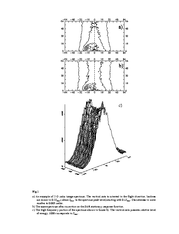
Fig.1
a)
An example of 2-D radar image spectrum. The vertical axis is oriented in
the flight direction. Isolines are drawn in 0.2Smax (where
Smax
-is the spectrum peak level) starting with 0.1Smax. Discreteness
in wave number is 0.005 rad/m.
b)
The same spectrum after correction on the SAR stationary response function.
c) The high-frequency portion of the spectrum shown in frame b). The vertical axis presents relative level of energy; 1000 corresponds to Smax .
Fig.2:
In-situ wave
elevation spectra S(k), m3 (1) and omnidirectional radar
image spectra Ss(k)/<s>2,
normalized by the mean radar signal squared (2) taken on August 29 (a)
and September 7 (b).
c)
The wave-radar image MTF estimates for August 29 (solid line, W=8m/s)
and for September 7 (short dashed, W=12m/s), and their best fit
by power function of dimensionless wave frequency: M(k)=3.6(W/C)1.18
(long dashed).
Fig.3
On
the left. Scheme of Experiment August 28, 1991. ALMAZ-1 SAR image (#2396a,
12:16 GMT) inlaid in the AVHRR SST field (08:00 GMT). Also shown are the
numbers and positions of image subscenes used to calculate radar image
spectra, the wind direction, and the vessel routes. The following are presented
in more details: the southern part of radar image, and the image subcsenes
at points #4 and #22 with the wave systems direction shown by the arrows.
On the right. The sample of 2-D radar spectra. Discreteness in wavenumber is 0.005 rad/m. Isolines are drawn in 20% of the maximum energy level of all spectra. The arrows show the wavenumbers corresponding to local maxima of model spectra calculated with adiabatic approximation.
Fig.4
On
the left. Model surface current field (isolines are drawn in 0.5m/s.).
Also shown are: the radar image swath, the locations of spectra presented
in Fig. 3, and the ship path.
a)
wave rays of systems A and B;
b)
wave rays of the wind-driven wave system.
On
the right. The data of ship measurements along the route #15:
c)
Wind speed (solid line) and direction (dotted line),
d)
Temperature of water (Tw) and air (Ta),
e)
The variance of vertical displacement of the vessel (solid line) and the
wave elevation variance retrieved from radar spectra (opened circles).
Fig.5
On
the left. The Gulf Stream ALMAZ-1 SAR image (#2418d, August 29, 1991, 21:45
GMT) on a background of the AVHRR SST (Aug. 29, 06:36 GMT). Also shown
are: the vessel route and the numbering of radar image subscenes used for
spectra calculation. The upper-right panel displays general view of the
thermal front. The lower panels present an enlargement of the linear structures
and the wave spectra retrieved from radar image at points #1 and #10. The
symbols mark: A and B -linear structures; T -thermal
front; C - clouds; E -the site of in-situ wave measurements.
On the right. The sample of 2-D radar spectra. The symbols A and B mark local maxima corresponding to different wave systems. Isolines are drawn in 0.2Smax where Smax is the maximum level in this series of spectra. Discreteness in wavenumber is Dk=0.005 rad/m. The arrows show the wavenumbers corresponding to local maxima of model spectra calculated with adiabatic approximation.
Fig.6.
On
the left. Surface currents for Aug.29. Isolines of speed are drawn in 0.5
m/s. Also shown are the positions of image subscenes used to calculate
spectra presented in Fig. 5 and the ship route.
a)
Wave rays of system B; the arrow (W) shows wind direction.
b)
Wave rays of system A.
On
the right. Data from R/V VERNADSKY transect (August 29):
c)
Wind speed (solid line) and direction (dotted line) (z=21m).
d)
Surface current U, and the positions of radar image subcsenes.
e)
Cross current velocity gradient gradU.
g)
Sea surface temperature Tw (dashed) and air temperature Ta
at z=21m (solid).
g)
The variance of vertical displacement of the vessel (solid) and the wave
elevation variance retrieved from radar spectra (opened circles).
h)
Wave breaking intensity normalized by friction velocity cubed, Q/au*3.
Symbols A and B along with crosses show the positions of the linear structures.
Fig.7. AVHRR SST for September 4 and September 8, 1991 with radar image swath (September 7) overlaid.
Fig.8
On
the left. The Gulf Stream ALMAZ-1 SAR image (#2560a, September 7, 1991,
19:30 GMT) inlaid in the AVHRR SST field (September 4). Also shown are:
the vessel route, the numbering of image subcsenes used for spectra calculations,
and the GS front position on September 6 and September 7 according to ship
data. The lower panel presents an enlargement of the northern frame of
radar image showing (1)-convergence front, (2)- mottled texture.
On
the right. The sample of 2-D radar image spectra. Isolines are drawn in
0.2Smaxwhere
Smax
is the maximum level in this series of spectra. Discreteness in wavenumber
is Dk=0.005
rad/m. The arrows show wavenumber of the peak of model spectra calculated
with adiabatic approximation.
Fig.9
On
the left.
(a)
Wave rays overlaid on the surface current (isolines are drawn in 0.5m/s.).
Also shown are: the radar image swath, the locations of spectra presented
in Figure 8, and the ship route.
(b)
Wave spectra retrieved from radar image at points #1, #8, and #25.
On
the right. The data of ship measurements:
c)
Wind speed (solid line) and direction (dotted line)
d)
Surface current U, and radar image subscenes positions.
f)
Temperatures of water (Tw) and air (Ta) at 21m.
e) The variance of vertical displacement of the vessel (solid line) and the wave elevation variance retrieved from radar spectra (opened circles).