| Forest Fire Emissions |
|||||||||||||||||||||||||||||||
| A
spatially and temporally explicit model was developed to estimate forest fire emissions
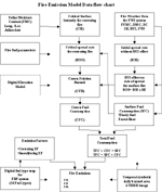
(Li, Z., J. Jin, and R.H. Fraser, 2000). The model consists of three components: daily
burned area mapping, fuel consumption estimation, and fire emissions estimation, Figure 1.
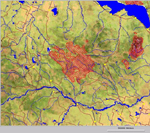
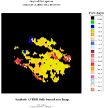
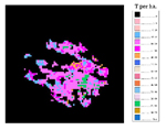
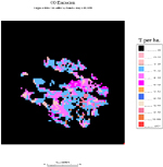
Wildfire on study area A massive forest fire that occurred in the Virginia Hills of central Alberta (116d07’W, 54d38’N) in 1998 served as a case study. The study area, lying within the Lower Foothill of the Boreal Forest region, comprises hardwood, softwood, and mixedwood stands, clear-cuts, regeneration, numerous regenerating burns, wetlands, small lakes, and seismic survey lines, Figure 2. A fire was detected in the area on May 3, 1998, which spread rapidly due to extreme fire weather conditions. The official estimate of the area damaged is 1,541 km2 (154,094 ha), the majority of which burned between May 4-5 before dying out on May 20. Daily burned area mapping A daily burned mapping algorithm was developed and applied to daily AVHRR images corresponding to the 18-days burning period (May 3 – May 20). Figure 3 shows the resulting cumulative burned area for each day. The identified burned pixels stamped with a given day will be linked to current fire weather data in order to estimate fuel consumption. Fuel consumption estimation Fuel consumption for the Virginia Hills fire was computed using the Canadian Forest Fire Danger Rating System, consisting of a Fire Weather Index (FWI) System (Van Wagner, 1987) and Fire Behavior Prediction (FBP) System (Forestry Canada Fire Danger Group, 1992). The FWI system, referring primarily to a standard pine fuel type, calculates fuel moisture codes and fire behavior indexes based on daily weather. The FBP system provides separate estimates of fire behavior for 16 fuel types based on the FWI and topography. The primary outputs of FBP system are rate of spread (m/min), fuel consumption (kg/m2), and fire intensity (kW/m). Three fuel types within the study area were mapped using a 1995 land cover classification derived from AVHRR imagery (Cihlar and Beaubien, 1998). Total fuel consumption (TFC) includes surface fuel consumption (SFC) and crown fuel consumption (CFC). The moisture codes and indices of FWI system, fuel types, and topography determine how much surface fuel is consumed, whether a crown fire occurs, and what fraction of the crown fuel is consumed [2]. Figure 4 presents a flowchart of the fuel consumption and fire emissions model. Figure 5 shows modelled fuel consumption for the Virginia Hills fire. Fire emissions estimation Emissions from the fire were estimated on a temporally explicit basis for each affected pixel using the following equation. Daily fire emission (t) = Fuel consumption (kg/m2) x Pixel area (km2) x Emission factor (g/kg), Emission factors, which relate the emission of gas x (g) to fuel consumption (kg), were obtained from Cofer et al. (1998). The emission factors were derived from smoke samples collected during the International Crown Fire Modelling Experiment in Northwest Territories, Canada. Figure 6 presents spatially explicit CO2 emissions over for the Virginia Hills fire. The table below summarises fuel consumption and fire emissions of three important trace gases from the Virginia Hills fire
References Li, Z., J. Jin, and R.H. Fraser, Mapping burning areas and estimating fire emissions over the Canadian boreal forest, Proceedings of the Joint Fire Science Conference and Workshop, Idaho, USA, June 15-17, 1999, Vol. 2, pages 247-251, 2000. Cofer III, W.R., E.L. Winstead, B.J. Stocks, J.G. Goldammer, and D.R. Cahoon, "Crown fire emissions of CO2, CO, H2, CH4, and TNMHC from a dense jack pine boreal forest fire," Geophysical Research Letters, Vol. 25, No. 21, pages 3919-3922, November 1,1998. Van Wagner, C.E., "Development and Structure of the Canadian Forest Fire Weather Index System," Canadian Forestry Service, Forestry Technical Report 35, Ottawa 1987. Forestry Canada Fire Danger Group, "Development and Structure of the Canadian Forest Fire Behavior Prediction System," Information Report ST-X-3, Published by Forestry Canada, Science and Sustainable Development Directorate, Ottawa, 1992. Cihlar, J., and J. Beaubien. 1998. Land cover of Canada Version 1.1. Special Publication, NBIOME Project. Produced by the Canada Centre for Remote Sensing and the Canadian Forest Service, Natural Resource s Canada. Available on CD-ROM from the Canada Centre for Remote Sensing, Ottawa, Ontario. |
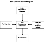 Figure 1.
Figure 2.
Figure 3.
Figure 4.
Figure 5.
Figure 6.
|