Modeling the Messinian Salinity Crisis:
Nearly 6 million years ago,
the Messinian Salinity Crisis (MSC) began when the connection
between the Atlantic Ocean and Mediterranean Sea was cut off. This
occurred due to a combination of lowered sea level of the global
oceans and collision between the European and African plates that
caused the land to lift. Normally there is much more evaporation
than precipitation over the Mediterranean Sea. This means that much
more water is leaving than entering the sea. Without a significant
source of water from the Atlantic Ocean, this led to the evaporation
much of the Mediterranean Sea. A large underground canyon formed
and rivers made deep incisions into the bottom of the basin. This
canyon was much larger than the Grand Canyon and had a depth of up
to 2,000 meters (6562 feet). We used the National Center for
Atmospheric Research (NCAR) Community Atmosphere Model version 3
(CAM3) to study how this event can affect the atmosphere and thus
the weather during this time period. Each simulation is run for 20
years and monthly averages over the last 10 years of each run were
calculated.
The control run simulates the
present day Mediterranean Sea but we do not allow the Atlantic Ocean
to transport any energy or heat into the Mediterranean Sea. This
was done because when the African and European continents collided
it isolated the Mediterranean Sea from the Atlantic Ocean.
Therefore, no heat or energy was transported into the Sea when the
MSC began. The Lowered Sea (LS) and Lowered Land (LL) are the two
experiments where the sea level was reduced over the Mediterranean
Sea. In the LL case the surface of the basin was converted to land
to simulate a completely dried up basin. We also tested the
sensitivity of creating land over the Mediterranean Sea in the model
by running an Upper Land (UL) simulation. In the UL case we changed
the sea points in the model to land points and added some vegetation
(mostly shrub and grassland), but the level of the surface was not
reduced.
|
CASE NAMES |
Messinian Event |
Description |
|
US |
Control |
Horizonal heat transport
through the strait is eliminated |
|
UL |
Sensitivity |
Same as US but now the
MS surface is converted to land to check the sensitivity of
removing the MS |
|
LS |
Lago-Mare |
Simulates the
Lago-Mare event, which occurred
near the end of the MSC. Water remains in the desiccated
basin. |
|
LL |
Deposition of Lower
Evaporites |
Simulates the middle of
the MSC when all of the water is believed to have evaporated
from the MS. |
Table 1. Describes
each of the 4 cases and how they relate to the MSC.
The Mediterranean Sea is
located between between 30oN and 45oN and
lies under the descending branch of the
Hadley cell circulation. The Hadley cell circulation brings
warm air from the tropics towards the poles. Near the equator,
warm air rises and is brought to the Earth's poles in the upper
layers of the atmosphere. The air cools and sinks near 30o
latitude in the Northern Hemisphere.
As air sinks in the atmosphere its pressure increases. When the
pressure increases, the molecules in the air are squeezed
tighter together and the molecules begin to collide.
Temperature is the measure of how fast the particles are hitting
each other, and the faster they hit each other, the greater the
temperature increases. As air sinks over the Mediterranean Sea
it heats up. Therefore there is high pressure and moderate
temperatures over the Mediterranean Sea. Its seasons range from
rainy and cool in the winter to warm and dry in the summer.
When the Mediterranean Sea's water level dropped 2000 meters the
surface pressure increased. (Fig. 1)
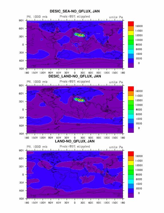
Figure 1: The difference in Surface Pressure between the three
cases (LS, LL, and UL) and the control (US).