Smoke plume detection
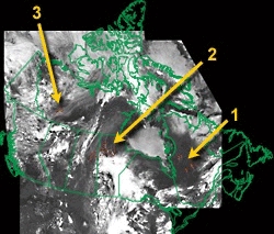
Figure 1. Fire Detection Image
A larger version is available:
June 25, 1995 (139kb
JPG)
In this study, satellite-based remote sensing techniques were developed for identifying
smoke from forest fires. Both artificial neural networks (NN) and multi-threshold
techniques were explored for application with imagery from the Advanced Very High
Resolution Radiometer (AVHRR) aboard NOAA satellites. The NN was designed such that
it does not only classify a scene into smoke, cloud, or clear background land, but also
generates continuous outputs representing the mixture portions of these objects?.
While the NN approach offers many advantages, it is time consuming for application over
large areas. A multi-threshold algorithm was thus developed as well. The two
approaches may be employed separately or in combination depending on the size of an image
and smoke conditions. The methods were evaluated in terms of Euclidean distance
between the outputs of the NN classification, using error matrices, visual inspection and
comparisons of classified smoke images with fire hot spots. They were applied to process
daily AVHRR images acquired across Canada. The results obtained in the 1998 fire
season were analyzed and compared with fire hot spots and TOMS-based aerosol index
data. Reasonable correspondence was found, but the signals of smoke detected by TOMS
and AVHRR are quite different but complementary to each other. In general, AVHRR is
most sensitive to low, dense smoke plumes located near fires, whereas smoke detected by
TOMS is dispersed, thin, elevated and further away from fires.
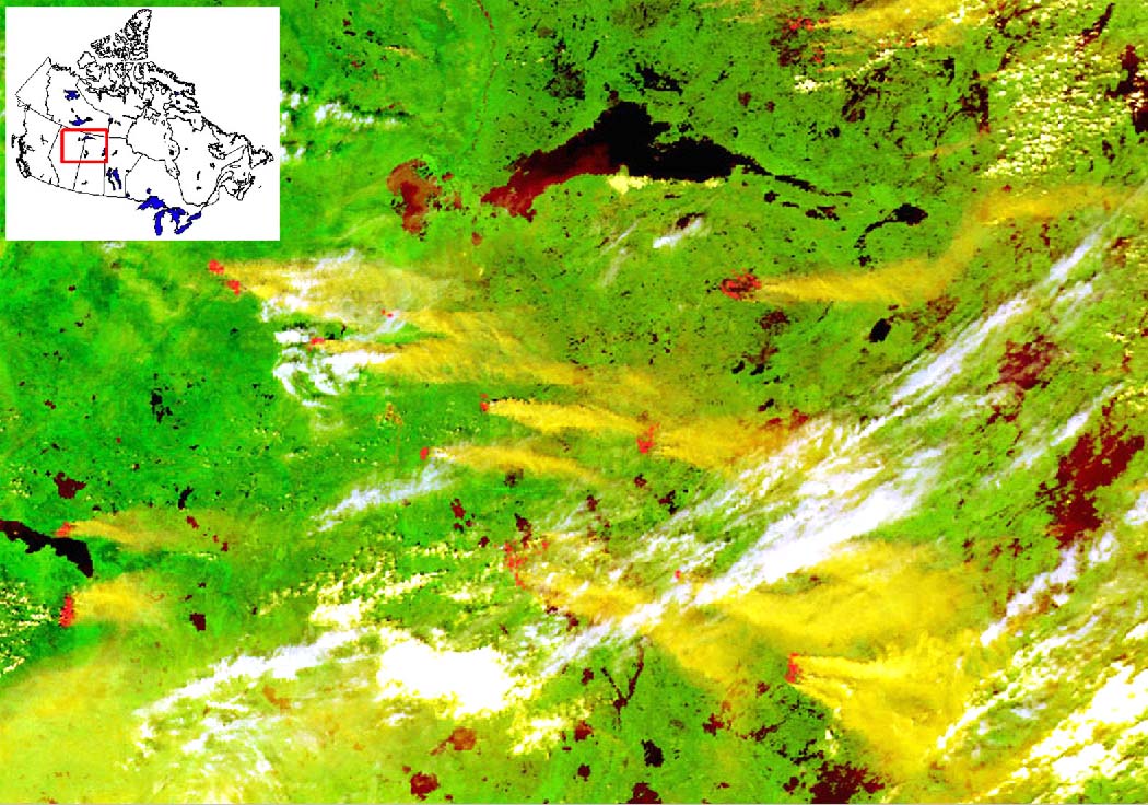
Comparison of Hot Spot and Smoke from AVHRR with TOMS Aerosol Index
We implemented the smoke detection algorithm to process daily
AVHRR imagery across Canada during the entire fire season (May-October) for a few years.
Shown here are results of comparisons with fire hot spot and TOMS based on TOMS-based
Aerosol Index (link to
http://toms.gsfc.nasa.gov) in 1998 when there were two major fire episodes that
occurred in July and August. The one in August is rather intensive and widespread.
In general, TOMS detects smoke with stronger signals downstream, whereas AVHRR is easier
to identify smoke near the source of a fire.
| Wild fires have a significant impact on vegetation dynamics. They are a
major disturbance to the boreal ecosystem and contribute to the increase in trace gases
that cause variations in climate. Fires also deplete timber resources so that monitoring
forest fires is a critical aspect of sustainable forest management. However, conventional
ground-based fire detection techniques are severely limited because they can only cover
small areas. Using NOAA-11 and NOAA-14 AVHRR images, researchers in the Environmental Monitoring Section, CCRS, have developed algorithms to detect forest fires. These could be used to provide daily satellite-based fire monitoring for Canada. The algorithms take advantage of information from multi-channel AVHRR measurements to determine the locations of active fires on satellite images (with pixels of about 1 km2) under clear sky or thin cloud conditions. Figure 1 is an example of an image showing forest fires across Canada detected by the NOAA-14 satellite on June 25, 1995. Smoke plumes from fires are clearly seen from AVHRR channel-1 measurements (background) and burning areas (red spots) are detected by the computer algorithm. Zoom-in images are available for the three regions indicated. The algorithms were applied to a data set containing more than 600 Canada-wide NOAA/AVHRR daily mosaics for the 1994, 1995, 1996 and 1997 fire seasons. The resulting product (Figure 1) permits a daily view of the situation for active fires across Canada.
|
|